
Hohnstein
Hohnstein | |
|---|---|
.jpg) | |
_Wappen.png) Coat of arms | |
Location of Hohnstein within Sächsische Schweiz-Osterzgebirge district 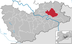 | |
 Hohnstein  Hohnstein | |
| Coordinates: 50°59′N 14°07′E / 50.983°N 14.117°E | |
| Country | Germany |
| State | Saxony |
| District | Sächsische Schweiz-Osterzgebirge |
| Government | |
| • Mayor | Sebastian Brade (UWU) |
| Area | |
| • Total | 64.61 km2 (24.95 sq mi) |
| Elevation | 330 m (1,080 ft) |
| Population (2022-12-31)[1] | |
| • Total | 3,201 |
| • Density | 50/km2 (130/sq mi) |
| Time zone | UTC+01:00 (CET) |
| • Summer (DST) | UTC+02:00 (CEST) |
| Postal codes | 01848 |
| Dialling codes | 035975 |
| Vehicle registration | PIR |
| Website | www.hohnstein.de |
Hohnstein is a town in the Sächsische Schweiz-Osterzgebirge district, in the Free State of Saxony, Germany. As of 2010 its population was of 3,671.
Geography
It is situated in Saxon Switzerland, 12 km east of Pirna, and 28 km southeast of Dresden (centre). It is dominated by its castle, standing on a sandstone rock.
Municipal territory includes the villages (Ortsteil) of Cunnersdorf, Ehrenberg, Goßdorf, Lohsdorf, Rathewalde, Ulbersdorf and Waitzdorf.
Gallery
-
1985 stamp of the castle.
-
 View of the town and the castle.
 -
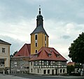 Town's church
 -
 Church in Rathewalde
 -
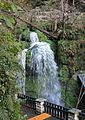 The Amsel Falls near Rathewalde


See also
- Hohnstein Castle (Saxon Switzerland)
- Schwarzbach Railway
- Goßdorf-Kohlmühle railway station
- Ulbersdorf railway station
References
- ^ "Einwohnerzahlen nach Gemeinden als Excel-Arbeitsmappe" (XLS) (in German). Statistisches Landesamt des Freistaates Sachsen. 2024.
External links
![]() Media related to Hohnstein at Wikimedia Commons
Media related to Hohnstein at Wikimedia Commons

_1985,_MiNr_2976.jpg)
| International | |
|---|---|
| National | |
| Geographic | |
This Sächsische Schweiz-Osterzgebirge location article is a stub. You can help Wikipedia by expanding it. |