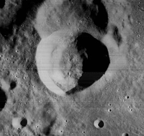
Horrebow (crater)
 Lunar Orbiter 4 image | |
| Coordinates | 58°42′N 40°48′W / 58.7°N 40.8°W |
|---|---|
| Diameter | 24 km |
| Depth | 2.5 km |
| Colongitude | 41° at sunrise |
| Eponym | Peder Horrebow |
Horrebow is a lunar impact crater that is located along the northern shore of Mare Frigoris, just to the south of the walled plain J. Herschel. To the west of Horrebow is the crater Robinson.
The crater is named after Peder Horrebow.[1]
Horrebow is roughly circular, but it has a narrower inner wall along the east and southeast sides than elsewhere around the perimeter. The inner walls have slumped, forming a ledge around the base of the slope. The interior floor is circular, but is offset to the east due to the asymmetry of the wall. The rim of the crater is sharp-edged, and is not significantly eroded.
The crater overlies the southwest part of a similar-sized crater with the designation Horrebow A. This satellite crater also joins the southeast rim of J. Herschel.
Satellite craters

By convention these features are identified on lunar maps by placing the letter on the side of the crater midpoint that is closest to Horrebow.
| Horrebow | Latitude | Longitude | Diameter |
|---|---|---|---|
| A | 59.2° N | 40.4° W | 25 km |
| B | 58.7° N | 42.7° W | 13 km |
| C | 56.9° N | 36.0° W | 5 km |
| D | 57.9° N | 38.7° W | 5 km |
| G | 59.7° N | 41.7° W | 8 km |
Notes
- ^ "Gazetteer of Planetary Nomenclature | Horrebow". usgs.gov. International Astronomical Union. Retrieved August 22, 2017.
References
- Andersson, L. E.; Whitaker, E. A. (1982). NASA Catalogue of Lunar Nomenclature. NASA RP-1097.
{{cite book}}: Invalid|ref=harv(help) - Blue, Jennifer (July 25, 2007). "Gazetteer of Planetary Nomenclature". USGS. Retrieved 2007-08-05.
{{cite web}}: Invalid|ref=harv(help) - Bussey, B.; Spudis, P. (2004). The Clementine Atlas of the Moon. New York: Cambridge University Press. ISBN 978-0-521-81528-4.
{{cite book}}: Invalid|ref=harv(help) - Cocks, Elijah E.; Cocks, Josiah C. (1995). Who's Who on the Moon: A Biographical Dictionary of Lunar Nomenclature. Tudor Publishers. ISBN 978-0-936389-27-1.
{{cite book}}: Invalid|ref=harv(help) - McDowell, Jonathan (July 15, 2007). "Lunar Nomenclature". Jonathan's Space Report. Retrieved 2007-10-24.
{{cite web}}: Invalid|ref=harv(help) - Menzel, D. H.; Minnaert, M.; Levin, B.; Dollfus, A.; Bell, B. (1971). "Report on Lunar Nomenclature by the Working Group of Commission 17 of the IAU". Space Science Reviews. 12 (2): 136–186. Bibcode:1971SSRv...12..136M. doi:10.1007/BF00171763.
{{cite journal}}: Invalid|ref=harv(help) - Moore, Patrick (2001). On the Moon. Sterling Publishing Co. ISBN 978-0-304-35469-6.
{{cite book}}: Invalid|ref=harv(help) - Price, Fred W. (1988). The Moon Observer's Handbook. Cambridge University Press. ISBN 978-0-521-33500-3.
{{cite book}}: Invalid|ref=harv(help) - Rükl, Antonín (1990). Atlas of the Moon. Kalmbach Books. ISBN 978-0-913135-17-4.
{{cite book}}: Invalid|ref=harv(help) - Webb, Rev. T. W. (1962). Celestial Objects for Common Telescopes (6th revised ed.). Dover. ISBN 978-0-486-20917-3.
{{cite book}}: Invalid|ref=harv(help) - Whitaker, Ewen A. (1999). Mapping and Naming the Moon. Cambridge University Press. ISBN 978-0-521-62248-6.
{{cite book}}: Invalid|ref=harv(help) - Wlasuk, Peter T. (2000). Observing the Moon. Springer. ISBN 978-1-85233-193-1.
{{cite book}}: Invalid|ref=harv(help)
