
Horseshoe Bend (Arizona)
Horseshoe Bend is the name for a horseshoe-shaped meander of the Colorado River located near the town of Page, Arizona, in the United States. It is located 5 miles (8.0 km) downstream from the Glen Canyon Dam and Lake Powell within Glen Canyon National Recreation Area, about 4 miles (6.4 km) southwest of Page. Accessible via a 1⁄2-mile (0.8 km) hike from U.S. Route 89, it can be viewed from the steep cliff above. According to Google terrain maps, the overlook is 4,200 feet (1,300 m) above sea level and the Colorado River is at 3,200 feet (980 m) above sea level making it a 1,000 feet (300 m) drop.
How to get there
The Horseshoe Bend parking lot is located 4 miles south of the Glen Canyon dam on the west side. The hiking sign is small and easy to miss, but the parking lot is easy to see from the road. Hike west 3/4 of the mile over loose sand and Navajo sandstone and you will be at the edge.
Tips
During the summer months this area will get very hot during mid-day. Be sure to bring plenty of water and wear good hiking shoes. The best time to photograph is 1-3pm during the summer months, as the light reaches deep into the canyon (or considering bracketing.) You will need a very wide angle lens to photograph the bend in its entirety.
Gallery
-
 Horseshoe Bend at 8pm on Aug 27 '12 (Post Adobe LR4)
 -
 Horseshoe Bend HDR
 -
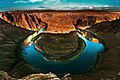
 Horseshoe bend seen from the lookout point
 -
 Horseshoe bend at sunrise
 -
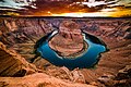
 Horseshoe Bend on sunny afternoon


Official Website
External links
![]() Media related to Horseshoe Bend (Arizona) at Wikimedia Commons
Media related to Horseshoe Bend (Arizona) at Wikimedia Commons
- Horseshoe Bend in a thunder storm
- Horseshoe bend at sunrise
- Horseshoe Bend Panorama
- Horseshoe Bend in B&W
- Horsheshoe Bend HDR
36°52′46″N 111°30′50″W / 36.87944°N 111.51389°W
This Arizona state location article is a stub. You can help Wikipedia by expanding it. |