
Hurricane Juliette (2001)
| Category 4 major hurricane (SSHWS/NWS) | |
 Hurricane Juliette off the coast of Mexico | |
| Formed | September 21, 2001 |
|---|---|
| Dissipated | October 3, 2001 |
| Highest winds | 1-minute sustained: 145 mph (230 km/h) |
| Lowest pressure | 923 mbar (hPa); 27.26 inHg |
| Fatalities | 12 total |
| Damage | $400 million (2001 USD) |
| Areas affected | Baja California, Northwestern Mexico |
| Part of the 2001 Pacific hurricane season | |
Hurricane Juliette was a long lasting Category 4 hurricane in the 2001 Pacific hurricane season. It caused 12 deaths and $400 million (2001 USD; $688 million 2024 USD) in damage when it hit Baja California in late September.[1]
Meteorological history

Tropical storm (39–73 mph, 63–118 km/h)
Category 1 (74–95 mph, 119–153 km/h)
Category 2 (96–110 mph, 154–177 km/h)
Category 3 (111–129 mph, 178–208 km/h)
Category 4 (130–156 mph, 209–251 km/h)
Category 5 (≥157 mph, ≥252 km/h)
Unknown
The tropical wave that later produced Juliette first produced Tropical Depression Nine in the Atlantic Ocean. Forming in the Caribbean Sea, the depression dissipated over Central America on September 20, a day after formation. By early on September 21, the remnants of Nine had re-organized in Pacific, and was then upgraded into a tropical depression.[2] Six hours later, the depression was upgraded into a tropical storm.[2] However, the storm was not named Juliette until later that day, when the storm was operationally believed to have formed (which came after reports from a Hurricane Hunter aircraft).[3]
In an environment of light wind shear, meteorologists predicted to new system to reach hurricane intensity within two days.[4] Within 100 mi (160 km) off the coast of Guatemala, the system moved generally west-northwest over the next five days, paralleling the Mexican Riviera.[2] While a major decrease in thunderstorm activity initially inhibited intensification[5] it became better organized on September 22.[6] By the afternoon of September 23, Juliette had become a hurricane, with maximum sustained winds reaching 75 mph (120 km/h).[2]
Upon becoming a hurricane, infrared imagery suggested that the hurricane had developed a pinhole eye. Forecasters were also expecting Juliette to reach major hurricane status, Category 3 or higher on the Saffir-Simpson Hurricane Scale. Steadily moving west, the storm underwent rapid deepening.[7][8] By 1800 UTC September 23, Juliette had reached Category 2 status, with winds of 100 mph (145 km/h). Shortly thereafter, the hurricane intensified into a Category 4 storm; bypassing the Category 3 stage, an unusual occurrence for a tropical cyclone. In all, Juliette had intensified 60 mph (130 km/h) in 18 hours.[2]

After reaching its secondary peak as a low-end Category 4 hurricane, microwave and Hurricane Hunter data indicated that Juliette underwent an eyewall replacement cycle. Subsequently, Juliette weakened into a Category 3 hurricane on September 24, and then into a high-end Category 2 system, with 110 mph (160 km/h) winds.[2] However, by September 25, Juliette had completed the cycle, and quickly regained major hurricane status.[9] The hurricane developed very cold cloud top temperatures.[10] along with a classic structure of an intense hurricane and a very well-defined eye.[11] A large hurricane,[12] Juliette reached its peak intensity of 145 mph (230 km/h) the same day.[2] Around that time, Reconnaissance Aircraft reported a minimum central pressure of 923 mbar.[12]
Shortly after its peak, a strong trough of low pressure brought Hurricane Juliette northward, where the cyclone moved over cooler water temperatures.[2] While Juliette initially maintained well-defined banding features and an impressive upper-level outflow,[13] another eyewall replacement cycle took its toll on the storm, this time three centric eyewalls formed compared to the normal two, a very rare occurrence.[14] Moving much further east than anticipated,[15] an eye was no longer visible on satellite imagery by September 27.[16]
Juliette slowed its forward motion as it continued north-northwestward, and weakened to a tropical storm on September 28.[2] Even though thunderstorm activity decreased markedly, Tropical Storm Juliette maintained a well-defined atmospheric circulation and a large area of gale-force winds.[17][18] A small area of warm waters near the Baja California Peninsula allowed the storm to re-strengthen into a hurricane early on September 29 as convection increased. At this time, computer models suggested two distinct possibilities of the storm's path. Some suggested Hurricane Juliette to move inland while others expected the hurricane to parallel the peninsula.[19]
Meandering offshore, the center soon became difficult to locate.[20] The low-level circulation became exposed from the deep convection[21] as increased vertical shear again took its toll on Juliette, and the storm hit Baja California near Cabo San Lucas as a minimal tropical storm at 0000 UTC September 30. Although scientists noted the possibility of slight re-intensification over the Gulf of California,[22] Juliette's low level circulation remained as it crossed the peninsula, and it restrengthened in the northern Gulf of California[2] as the circulation became better defined.[23] Lacking deep convection,[24] it drifted westward, where, after making a landfall in northeastern Baja California, it finally dissipated early on October 3.[2]
Preparations
Not long after Juliette was designated as a tropical storm on September 21, the Government of Mexico issued a tropical storm warning for areas between Salina Cruz and Acapulco and a tropical storm watch for areas west of Acapulco to Lázaro Cárdenas, Michoacán. Later that day, the warning was updated to include areas through Zihuatanejo and a watch through Manzanillo, Colima. Once Juliette turned westward and no longer posed a threat to the country, all watches and warnings were discontinued by the afternoon of September 22. However, due to the system's slow, erratic track on September 23, a hurricane watch and tropical storm warning was issued for areas between Lázaro Cárdenas and Cabo Corrientes. These advisories remained in place through the afternoon of September 25, by which time Juliette had picked up forward momentum and tracked northwestward. By September 26, the hurricane threatened land once more, prompting watches and warnings for the Baja California Peninsula. Initially, only a tropical storm watch was issued for the southern tip of Baja California Sur but, as the storm neared the peninsula, more extensive advisories were declared. By the morning of September 27, a hurricane warning covered much of both coasts of Baja California Sur as the storm was forecast to track directly through the state. The following day, a tropical storm warning was issued for areas between Mazatlán and Yavaros in Sonora but, this was discontinued later that day. As the storm stalled offshore and weakened, all hurricane warnings were replaced with tropical storm warnings which were later canceled once Juliette weakened to a tropical depression.[2] Forecasters also noted the possibility of moisture spreading into the Southwestern portion of the United States.[24]
Impact

Southern Mexico
Along coastal areas around Acapulco, the storm brought heavy rainfall and strong winds.[25] Offshore, one fisherman was killed by the storm after he set sail directly into it. In Guerrero, heavy rains triggered flash floods that washed out two bridges and destroyed 20 homes.[26] As rains continued to fall over the following days, mountainsides gave way, producing landslides which killed seven people. Strong winds also uprooted trees and downed power lines in several states. Additionally, two fishermen were listed as missing after venturing out into 5 m (16 ft) swells produced by Juliette.[27] Throughout Michoacán, an estimated 1,000 people were left homeless by the hurricane.[28]
Baja California
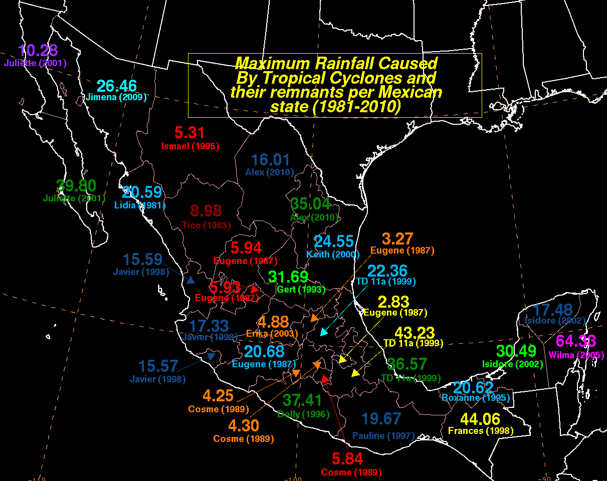
As Hurricane Juliette stalled just off the coast of Baja California Sur, it produced prolonged heavy rainfall in the region. A large swath of the state, along the eastern coast, received more than 10 in (250 mm) of rain and areas along the southern tip reported more than 20 in (510 mm). A maximum of 39.8 in (1,010 mm) fell in Caudaño,[29] the highest known total ever recorded from a tropical cyclone in the state.[30]
The extreme rainfall led to widespread flooding and mudslides across the state. Along the southern tip of the peninsula, roughly 3,000 people were stranded after their town was isolated by flood waters. About 800 more people had to be evacuated due to the state of their homes.[31] Damage from the floods were widespread in the area, with more than 9,000 people reported damage to their property from the storm. At least two people were killed across the peninsula in storm-related incidents.[32] Damage from Hurricane Juliet was estimated at $400 million (2001 USD; $688 million 2024 USD).[33]
Northern Mexico and the United States
Late in Juliette's life and in its aftermath, the remnants brought strong thunderstorm activity to the American Southwest, knocking down trees and power lines in southern California. Rainfall in the United States peaked at 0.9 inches in Patagonia, Arizona.[34]
Aftermath and records
Following the significant damage across southern states, Mexican authorities and the army deployed transport and rescue aircraft along with medical teams and emergency supplies.[28] As reports of damage began come out of Baja California Sur, the state governor declared the entire area a disaster zone.[31]
At its peak, Juliette attained a minimum pressure of 923 mbar (hPa; 27.26 inHg), ranking it as the fifth strongest Pacific hurricane on record, along with Olivia in 1994. However, in subsequent years, five other storms have surpassed it and the storm now ranks as the tenth strongest in the basin. At the time, it held the record for having the lowest barometric pressure of any Category 4 hurricane in the region, a record shared with Olivia; it has since been surpassed by Odile in 2014 with a minimum pressure of 918 mbar (hPa; 27.23 inHg) .[35]
See also
References
- ^ Diapositiva 1
- ^ a b c d e f g h i j k l Lawrence, Miles; Mainelli (November 30, 2001). "Hurricane Juliette Tropical Cyclone Report". National Hurricane Center. National Oceanic and Atmospheric Administration. Retrieved July 7, 2010.
- ^ Franklin, James (September 21, 2001). "Tropical Storm Juliette Discussion 1". National Hurricane Center. National Oceanic and Atmospheric Administration. Retrieved May 12, 2012.
- ^ Lawrence, Miles; Holweg (September 21, 2001). "Tropical Storm Juliette Discussion 2". National Hurricane Center. National Oceanic and Atmospheric Administration. Retrieved May 12, 2012.
- ^ Stewart, Stacey (September 22, 2001). "Tropical Storm Juliette Discussion 4". National Hurricane Center. National Oceanic and Atmospheric Administration. Retrieved May 12, 2012.
- ^ Stewart, Stacey (September 22, 2001). "Tropical Storm Juliette Discussion 7". National Hurricane Center. National Oceanic and Atmospheric Administration. Retrieved May 12, 2012.
- ^ Avila, Lixon (September 23, 2001). "Hurricane Juliette Discussion 9". National Hurricane Center. National Oceanic and Atmospheric Administration. Retrieved May 12, 2012.
- ^ Avila, Lixon (September 23, 2001). "Hurricane Juliette Discussion 10". National Hurricane Center. National Oceanic and Atmospheric Administration. Retrieved May 12, 2012.
- ^ Stacey, Stewart (September 25, 2001). "Hurricane Juliette Discussion 16". National Hurricane Center. National Oceanic and Atmospheric Administration. Retrieved May 12, 2012.
- ^ Stacey, Stewart (September 25, 2001). "Hurricane Juliette Discussion 17". National Hurricane Center. National Oceanic and Atmospheric Administration. Retrieved May 12, 2012.
- ^ Pasch, Robert (September 25, 2001). "Hurricane Juliette Discussion 18". National Hurricane Center. National Oceanic and Atmospheric Administration. Retrieved May 12, 2012.
- ^ a b Pasch, Robert (September 25, 2001). "Hurricane Juliette Discussion 19". National Hurricane Center. National Oceanic and Atmospheric Administration. Retrieved May 12, 2012.
- ^ Avila, Lixon; Mianelli (September 26, 2001). "Hurricane Juliette Discussion 22". National Hurricane Center. National Oceanic and Atmospheric Administration. Retrieved May 12, 2012.
- ^ Beven, Jack (September 27, 2001). "Hurricane Juliette Discussion 24". National Hurricane Center. National Oceanic and Atmospheric Administration. Retrieved May 12, 2012.
- ^ Avila, Lixon (September 27, 2001). "Hurricane Juliette Discussion 25". National Hurricane Center. National Oceanic and Atmospheric Administration. Retrieved May 12, 2012.
- ^ Franklin, James; Mianelli (September 27, 2001). "Hurricane Juliette Discussion 26". National Hurricane Center. National Oceanic and Atmospheric Administration. Retrieved May 12, 2012.
- ^ Avila, Lixon (September 28, 2001). "Hurricane Juliette Discussion 30". National Hurricane Center. National Oceanic and Atmospheric Administration. Retrieved May 12, 2012.
- ^ Avila, Lixon (September 28, 2001). "Hurricane Juliette Discussion 31". National Hurricane Center. National Oceanic and Atmospheric Administration. Retrieved May 12, 2012.
- ^ Beven, Jack (September 29, 2001). "Hurricane Juliette Discussion 32". National Hurricane Center. National Oceanic and Atmospheric Administration. Retrieved May 12, 2012.
- ^ Avila, Lixon (September 29, 2001). "Hurricane Juliette Discussion 34". National Hurricane Center. National Oceanic and Atmospheric Administration. Retrieved May 12, 2012.
- ^ Beven, Jack (September 30, 2001). "Hurricane Juliette Discussion 36". National Hurricane Center. National Oceanic and Atmospheric Administration. Retrieved May 12, 2012.
- ^ Pasch, Robert; Rappaport (September 30, 2001). "Hurricane Juliette Discussion 39". National Hurricane Center. National Oceanic and Atmospheric Administration. Retrieved May 12, 2012.
- ^ Franklin, James (October 1, 2001). "Hurricane Juliette Discussion 41". National Hurricane Center. National Oceanic and Atmospheric Administration. Retrieved May 12, 2012.
- ^ a b Beven, Jack (October 1, 2001). "Hurricane Juliette Discussion 42". National Hurricane Center. National Oceanic and Atmospheric Administration. Retrieved May 12, 2012.
- ^ Associated Press (September 23, 2001). "Hurricane Juliette gathers strength, hits Mexican coast". ReliefWeb. Retrieved July 7, 2010.
- ^ Agence France-Presse (September 24, 2001). "Hurricane Juliette leaves one dead, destruction in its wake". ReliefWeb. Retrieved July 7, 2010.
- ^ Deutsche Presse Agentur (September 26, 2001). "Hurricane Juliette leaves seven dead in Mexico". ReliefWeb. Retrieved July 7, 2010.
- ^ a b United Nations Office for the Coordination of Humanitarian Affairs (September 28, 2001). "OCHA Situation Report No. 4". ReliefWeb. Retrieved July 7, 2010.
- ^ Roth, David. "Hurricane Juliette - September 25-October 3, 2001". Hydrometeorological Prediction Center. National Oceanic and Atmospheric Administration. Retrieved July 7, 2010.
- ^ Roth, David (2010). "Tropical Cyclone Maxima Per Mexican State". Hydrometeorological Prediction Center. Retrieved July 7, 2010.
- ^ a b United Nations Office for the Coordination of Humanitarian Affairs (September 29, 2001). "Mexico - Hurricane Juliette OCHA Situation Report No. 5". ReliefWeb. Retrieved July 7, 2010.
- ^ Deutsche Presse Agentur (September 29, 2001). "Hurricane "Juliette" leaves two dead in Mexico's Baja California". ReliefWeb. Retrieved July 7, 2010.
- ^ Centre for Research on the Epidemiology of Disasters. "EM-DAT: The Emergency Events Database". Université catholique de Louvain.
- ^ Roth, David M. (January 3, 2023). "Tropical Cyclone Point Maxima". Tropical Cyclone Rainfall Data. United States Weather Prediction Center. Retrieved January 6, 2023.
 This article incorporates text from this source, which is in the public domain.
- ^ "Eastern North Pacific Tracks File 1949–2009". National Hurricane Center. 2010. Retrieved July 6, 2010.
External links
- NHC Report
- Juliette Best Track
- Juliette effects in Cabo San Lucas
- HPC rainfall report for Juliette
- Boating Effects
- Early Effects
- Michoacán Effects
- After Effects
Tropical cyclones of the 2001 Pacific hurricane season | ||
|---|---|---|
 | ||