
File:Approximate JR Areas.jpg
Size of this preview: 590 × 599 pixels. Other resolutions: 236 × 240 pixels | 472 × 480 pixels | 756 × 768 pixels.
Original file (756 × 768 pixels, file size: 167 KB, MIME type: image/jpeg)
| This is a file from the Wikimedia Commons. Information from its description page there is shown below. Commons is a freely licensed media file repository. You can help. |
from en:Image:Approximate JR Areas.jpg

|
File:JR Rail ja.svg is a vector version of this file. It should be used in place of this JPG file when not inferior.
File:Approximate JR Areas.jpg → File:JR Rail ja.svg
For more information, see Help:SVG. |
 |

|
Permission is granted to copy, distribute and/or modify this document under the terms of the GNU Free Documentation License, Version 1.2 or any later version published by the Free Software Foundation; with no Invariant Sections, no Front-Cover Texts, and no Back-Cover Texts. A copy of the license is included in the section entitled GNU Free Documentation License. |
| This file is licensed under the Creative Commons Attribution-Share Alike 3.0 Unported license. | ||
| ||
| This licensing tag was added to this file as part of the GFDL licensing update. |

|
This work includes material that may be protected as a trademark in some jurisdictions. If you want to use it, you have to ensure that you have the legal right to do so and that you do not infringe any trademark rights. See our general disclaimer. This tag does not indicate the copyright status of the attached work. A normal copyright tag is still required. See Commons:Licensing. |
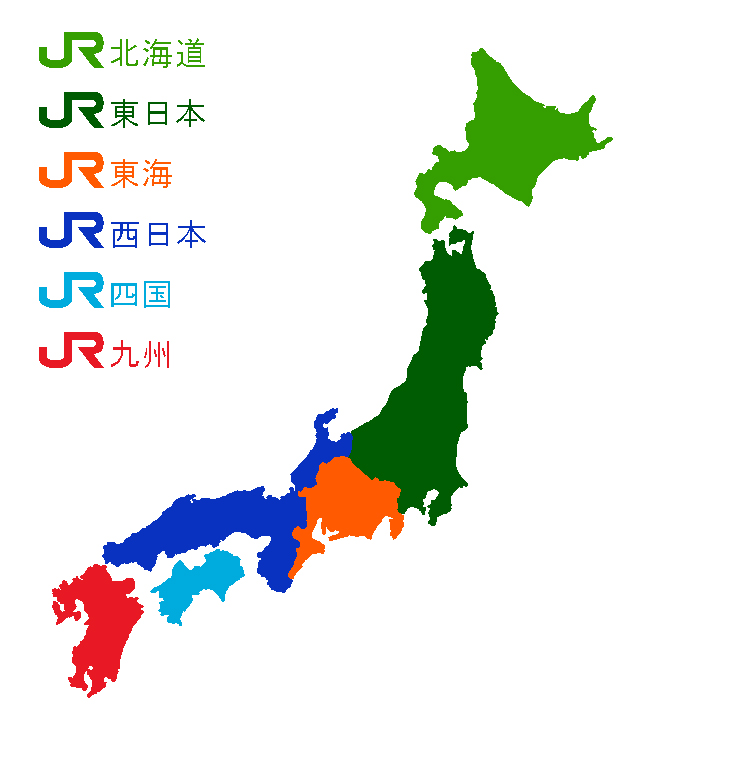
Map showing approximate areas that the JR Hokkaido (light green), JR East (dark green), JR Central (Tokai) (orange), JR West (dark blue), JR Shikoku (light blue), and JR Kyushu Companies (red) cover. JR Freight Co. is not listed as it covers all JR freight shipments in Japan.
File history
Click on a date/time to view the file as it appeared at that time.
| Date/Time | Thumbnail | Dimensions | User | Comment | |
|---|---|---|---|---|---|
| current | 07:03, 8 July 2005 | | 756 × 768 (167 KB) | ChongDae | from en:Image:Approximate JR Areas.jpg {{GFDL}} Map showing approximate areas that the JR Hokkaido, JR East, JR Central (Tokai), JR West, JR Shikoku, and JR Kyushu Companies cover. JR Freight Co. is not listed as it covers all JR freight shipments i |
File usage
No pages on the English Wikipedia use this file (pages on other projects are not listed).
Global file usage
The following other wikis use this file:
- Usage on zh-min-nan.wikipedia.org
- Usage on zh-yue.wikipedia.org
- Usage on zh.wikipedia.org