
File:Scandinavia location map definitions.PNG

Size of this preview: 786 × 599 pixels. Other resolutions: 315 × 240 pixels | 630 × 480 pixels | 842 × 642 pixels.
Original file (842 × 642 pixels, file size: 15 KB, MIME type: image/png)
| This is a file from the Wikimedia Commons. Information from its description page there is shown below. Commons is a freely licensed media file repository. You can help. |
Fdirujl
Summary
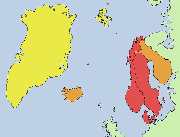
Map showing Scandinavia using different definitions:
the intra-Nordic usage: the three monarchies
the extended usage: Nordic region, except Greenland and Svalbard
the maximal extent: synonymous with the entire Nordic region although Greenland is part of North America
Licensing
I, the copyright holder of this work, hereby publish it under the following licenses:

|
Permission is granted to copy, distribute and/or modify this document under the terms of the GNU Free Documentation License, Version 1.2 or any later version published by the Free Software Foundation; with no Invariant Sections, no Front-Cover Texts, and no Back-Cover Texts. A copy of the license is included in the section entitled GNU Free Documentation License. |
| This file is licensed under the Creative Commons Attribution-Share Alike 3.0 Unported license. | ||
| ||
| This licensing tag was added to this file as part of the GFDL licensing update. |
You may select the license of your choice.
File history
Click on a date/time to view the file as it appeared at that time.
| Date/Time | Thumbnail | Dimensions | User | Comment | |
|---|---|---|---|---|---|
| current | 02:30, 4 February 2007 | | 842 × 642 (15 KB) | Tene~commonswiki | Optimised (0;r) |
| 13:00, 1 July 2006 |  | 842 × 642 (31 KB) | Roke~commonswiki | less saturated colours, details in denmark islands | |
| 02:40, 10 April 2006 |  | 842 × 642 (31 KB) | Roke~commonswiki | 3 colours | |
| 02:39, 10 April 2006 |  | 842 × 642 (30 KB) | Roke~commonswiki | better map, 2 colours | |
| 14:18, 2 April 2006 |  | 555 × 340 (9 KB) | Roke~commonswiki | Map showing Scandinavia using different definitions: * dark blue = the intra-Nordic usage: the three monarchies * medium blue = the extended usage: Nordic region, except Greenland and Svalbard * light blue = the maximal extent: synonymous wi |
File usage
The following pages on the English Wikipedia use this file (pages on other projects are not listed):
Global file usage
The following other wikis use this file:
- Usage on af.wikipedia.org
- Usage on arz.wikipedia.org
- Usage on bn.wikipedia.org
- Usage on ca.wikipedia.org
- Usage on cs.wikipedia.org
- Usage on da.wikipedia.org
- Usage on de.wikipedia.org
- Usage on diq.wikipedia.org
- Usage on dsb.wikipedia.org
- Usage on el.wikipedia.org
- Usage on en.wiktionary.org
- Usage on gd.wikipedia.org
- Usage on hi.wikipedia.org
- Usage on it.wikipedia.org
- Usage on ka.wikipedia.org
- Usage on kn.wikipedia.org
- Usage on ko.wikipedia.org
- Usage on lv.wikipedia.org
- Usage on mk.wikipedia.org
- Usage on mr.wikipedia.org
- Usage on ms.wikipedia.org
- Usage on nl.wikipedia.org
- Usage on oc.wikipedia.org
- Usage on os.wikipedia.org
- Usage on pt.wikipedia.org
- Usage on ro.wikipedia.org
- Usage on sk.wikipedia.org
- Usage on sq.wikipedia.org
- Usage on sr.wikipedia.org
- Usage on vec.wikipedia.org
- Usage on zh.wikipedia.org
View more global usage of this file.