File:Sed localities.png

Original file (3,208 × 3,621 pixels, file size: 283 KB, MIME type: image/png)
Summary
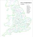
[edit]A map of England showing the approximate geographical positions and names of the localities that were included in the Survey of English Dialects. Brought to you by www.nicoledidi.ch. The map was produced by means of a simple php script that painted dots in the right places. If anyone would like to create symbol maps with material from the Survey of English Dialects, he or she is invited to contact me. Symkyn 08:27, 21 April 2007 (UTC)
Licensing
[edit]| I, the copyright holder of this work, hereby release it into the public domain. This applies worldwide. If this is not legally possible: |
 | This file is a candidate to be copied to Wikimedia Commons.
Any user may perform this transfer; refer to Wikipedia:Moving files to Commons for details. If this file has problems with attribution, copyright, or is otherwise ineligible for Commons, then remove this tag and DO NOT transfer it; repeat violators may be blocked from editing. Other Instructions
| ||
| |||
File history
Click on a date/time to view the file as it appeared at that time.
| Date/Time | Thumbnail | Dimensions | User | Comment | |
|---|---|---|---|---|---|
| current | 08:20, 25 April 2007 |  | 3,208 × 3,621 (283 KB) | Symkyn (talk | contribs) | A map of England showing the approximate geographical positions and names of the localities that were included in the Survey of English Dialects. Brought to you by [http://www.nicoledidi.ch/ www.nicoledidi.ch]. The map was produced by means of a simpl |
| 08:27, 21 April 2007 |  | 3,208 × 3,621 (283 KB) | Symkyn (talk | contribs) | A map of England showing the approximate geographical positions and names of the localities that were included in the Survey of English Dialects. Brought to you by [http://www.nicoledidi.ch/ www.nicoledidi.ch]. The map was produced by means of a simpl |
You cannot overwrite this file.
File usage
The following page uses this file:
