
File:US insular areas.png

Original file (1,482 × 624 pixels, file size: 39 KB, MIME type: image/png)
| This is a file from the Wikimedia Commons. Information from its description page there is shown below. Commons is a freely licensed media file repository. You can help. |

|
File:US insular areas.svg is a vector version of this file. It should be used in place of this PNG file when not inferior.
File:US insular areas.png → File:US insular areas.svg
For more information, see Help:SVG. |
 |
Summary
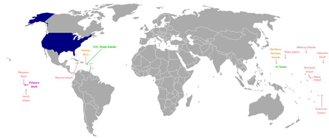
This is a map of the US Insular areas. The first version of this map was based off Image:BlankMap-World-v6.png by User:Astrokey44 with the locations of a few islands added; the source for this are two CIA maps; the maps are a map of the Pacific region and a map of the United States Pacific Island Wildlife Refuges. Hawaii has also been added to the map. Names of the islands are from the CIA Factbook. The second version is based off Image:Dependent_territories_2007.png by User:Sesmith. This map is color-coded according to each island's status:
For an uncolor-coded map, see Image:US_insular_areas-B.png. For a version with the freely associated states, see Image:US_insular_areas FAS.png.
The previous map is under the GFDL; because of this, this map is also.
Licensing

|
Permission is granted to copy, distribute and/or modify this document under the terms of the GNU Free Documentation License, Version 1.2 or any later version published by the Free Software Foundation; with no Invariant Sections, no Front-Cover Texts, and no Back-Cover Texts. A copy of the license is included in the section entitled GNU Free Documentation License. |
| This file is licensed under the Creative Commons Attribution-Share Alike 3.0 Unported license. | ||
| ||
| This licensing tag was added to this file as part of the GFDL licensing update. |
File history
Click on a date/time to view the file as it appeared at that time.
| Date/Time | Thumbnail | Dimensions | User | Comment | |
|---|---|---|---|---|---|
| current | 06:35, 2 August 2014 | | 1,482 × 624 (39 KB) | KronosLine | Fix Ukraine, the Caucasus, and added South Sudan. |
| 04:52, 5 March 2008 |  | 1,482 × 624 (52 KB) | Hoshie | rebuilt using User:Sesmith's maps; more to come. | |
| 10:38, 17 March 2007 |  | 1,482 × 624 (32 KB) | Hoshie | This is a map of the US Insular areas. The base map is Image:BlankMap-World-v6.png by User:Astrokey44 with the locations of a few islands added; the source for this are two CIA maps; the maps are a [https://www.cia.gov/cia/publications/factbook/ |
File usage
Global file usage
The following other wikis use this file:
- Usage on ast.wikipedia.org
- Usage on es.wikipedia.org
- Usage on vi.wikipedia.org
- Usage on www.wikidata.org