Indiana Territory's at-large congressional district
Appearance

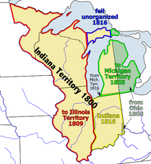
The Indiana Territory's At-large congressional district encompassed the entire area of the Indiana Territory. A delegate to the United States Congress was elected from this district. The territory was created from portions of the Northwest Territory leading up to the State of Ohio achieving statehood.
List of delegates
The territory sent one non-voting delegate to the United States House of Representatives.
| Delegate | Years | Party | District home | Note |
|---|---|---|---|---|
 Benjamin Parke Benjamin Parke
|
December 12, 1805 – March 1, 1808 | none | ||
 Jesse Burgess Thomas Jesse Burgess Thomas
|
October 22, 1808 – March 3, 1809 | Democratic-Republican | ||
 Jonathan Jennings Jonathan Jennings
|
November 27, 1809 – December 11, 1816 | none |
The area of Indiana Territory was reduced in 1805 by the creation of Michigan Territory, and again in 1809 by the creation of Illinois Territory. On December 11, 1816, Indiana was admitted into the Union as a state.
