Jewish cemetery, Besançon
| Jewish cemetery of Besançon | |
|---|---|
 | |
 | |
| Details | |
| Established | 1796 |
| Location | |
| Country | France |
| Type | Judaism |
| Owned by | Jew community of Besançon |
| Size | 935m² |
| No. of graves | 600 (est.) |
| No. of interments | 600 (est.) |
| No. of cremations | 0 |
The Jewish cemetery of Besançon is located in the French city of Besançon. It is the only Jewish cemetery in the département of Doubs.
History
The Jewish cemetery of Besançon is located on Anne Frank street, between the Bregille and Palente areas, in the northwest part of the city. The older part of the cemetery was procured by two notaries of the Jewish community of Besançon, in 1796. In 1839 the cemetery was expanded. The earliest graves date from 1849, and the cemetery is still in use. At the entrance of the cemetery a memorial commemorates the members of the Jewish community of Besançon killed during the First World War. Today the cemetery holds between 400 and 600 graves, in an area measuring about 935 m².[1]
Gallery
-
General view of the cemetery.
-
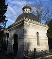
A mausoleum.
-
A "pyramidal tomb".
-
Tomb of the Picard-Hauser family.
-
Tomb of the Haas family.
-
An other tomb.
-
An other tomb.
See also
References
- ^ Template:Fr The Jewish cemetery of Besançon in Migrations.Besancon.fr, 3rd paragraph. (viewed 26 February 2010).
External links
Template:Fr History of the Jewish community of Besançon (Migrations.Besancon.fr)


