John Muir Country Park

The John Muir Country Park is an area of woodland, grassland and coastline near Dunbar in East Lothian, Scotland. It is named after John Muir, a famous naturalist and geologist who was born in Dunbar and later emigrated to the United States, where he developed his ideas.
Designated in 1976, the park covers 7.73 square kilometres, stretching from Belhaven (just outside Dunbar) to Tyninghame. The park is home to a diverse collection of animal species, including several species of butterfly and moth and over 400 species of plants. The park is also ideal for birdwatching, with (depending on the season) kittiwake, eider duck, shelduck, skylark, meadow pipit, ringed plover, gannet, terns, sand martins, crossbill, wigeon, bar-tailed godwit and whooper swan to be seen.
Dunbar Castle

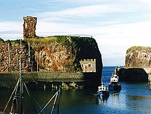
The ruins of Dunbar Castle are also within the park. Dunbar Castle was once one of the most important strategic buildings in Scotland and was the subject of many battles as Picts, Angles and others battled for control of the castle and surrounding area. Long after the advent of peace between Scotland and England, the remains of the castle were in the news again in 1842 when electrically fired demolition charges saw their first practical use - blasting a channel through the rock to serve as the entrance for the new Victoria Harbour. The castle has been allowed to disintegrate under the impact of wave and weather since 1567; major losses were sustained in 1868 and 1993 (collapses of walls), but minor losses occur annually. The remains are currently inaccessible to the public.
See also
External links
- John Muir's Legacy, The Scotsman
- John Muir Country Park from East Lothian Council
