K-W Line
This article relies largely or entirely on a single source. (August 2013) |

The K-W Line, and abbreviation for the full title of Koningshooikt-Wavre Line,[1] was the main Belgian line of defence against a possible German armoured invasion through the centre of Belgium, during the initial phase of the Second World War.
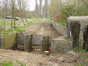
The K-W Line, also known as the Dyle Line (Dijle-line) (named after the river Dijle) or Iron Wall, was requested by the Belgian Ministry of Defence and built between September 1939 and May 1940. It consisted of a connection of bunkers and barricades between the village of Koningshooikt and the city of Wavre. The barricades were either Cointet-elements connected to each other with steel cables, railway tracks drilled partly into swampy areas, concrete ditches filled with water, or other steel constructions that could hold off armoured vehicle attacks.
In 2009, an inventory of surviving emplacements was begun.[2]
See also
References
- ^ Vanden Bloock, Bernard. "Belgian Fortifications, May 1940: KW Line (60 km)". niehorster.orbat.com. Retrieved 26 February 2013.
- ^ www.kwlinie.be
