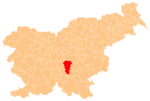
Kal, Ivančna Gorica
Appearance
Kal | |
|---|---|
 | |
| Coordinates: 45°49′54.34″N 14°48′35.08″E / 45.8317611°N 14.8097444°E | |
| Country | |
| Traditional region | Lower Carniola |
| Statistical region | Central Slovenia |
| Municipality | Ivančna Gorica |
| Area | |
| • Total | 5.39 km2 (2.08 sq mi) |
| Elevation | 403.1 m (1,322.5 ft) |
| Population (2002) | |
| • Total | 107 |
| [1] | |
Kal (pronounced [ˈkaːu̯]) is a small village just west of Ambrus in the Municipality of Ivančna Gorica in central Slovenia. The area is part of the historical region of Lower Carniola. The municipality is now included in the Central Slovenia Statistical Region.[2]
Church
[edit]
The local church is dedicated to Saint Lucy and belongs to the Parish of Ambrus. It was originally built in the 17th century, but largely rebuilt in 1836.[3] The church was badly damaged by Partisan forces in 1943.[4]
References
[edit]- ^ Statistical Office of the Republic of Slovenia
- ^ Ivančna Gorica municipal site
- ^ "EŠD 1603". Registry of Immovable Cultural Heritage (in Slovenian). Ministry of Culture of the Republic of Slovenia. Retrieved 4 August 2011.
- ^ "Cerkev na Kalu popolnoma razbita, šola na Korinju zažgana". Slovenski dom. No. 67. March 24, 1943. p. 5. Retrieved August 5, 2024.
External links
[edit] Media related to Kal at Wikimedia Commons
- Kal on Geopedia


