Kalvøyrevet Bridge
Appearance
Kalvøyrevet Bridge Kalvøyrevet bru | |
|---|---|
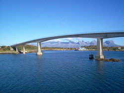
 View of the bridge (De syv søstre mountains in background) | |
| Coordinates | 65°59′51″N 12°15′55″E / 65.99750°N 12.26528°E |
| Carries | |
| Locale | Herøy, Nordland |
| Characteristics | |
| Design | Cantilever bridge |
| Material | Concrete |
| Total length | 298 metres (978 ft) |
| Longest span | 95 metres (312 ft) |
| Location | |
 | |
Kalvøyrevet Bridge (Template:Lang-no) is a cantilever bridge in the municipality of Herøy in Nordland county, Norway. The concrete bridge is 298 metres (978 ft) long, and the main span is 95 metres (312 ft). As a part of Norwegian County Road 166, it connects the islands of Indre Øksningan and Ytre Øksningan with the rest of Herøy.[1]
See also
- List of bridges in Norway
- List of bridges in Norway by length
- List of bridges
- List of bridges by length
References
- ^ Kalvøyrevet Bridge at Structurae. Retrieved 2011-12-29.
