Kentuckiana
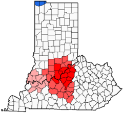
Kentuckiana also referred to as Indiucky on Indiana's side | |
|---|---|
 Additional areas considered a part of Kentuckiana Evansville Metropolitan area and Owensboro Metropolitan area, not commonly considered a part of Kentuckiana | |
| Country | |
| States | |
| Principal city | Louisville |
| Time zone | UTC-5 (EST) |
| • Summer (DST) | UTC-4 (EDT) |
Kentuckiana is a portmanteau term used to refer to an area in the Upland South region of the United States containing metropolitan areas with counties in both Kentucky and Indiana. The term is primarily used to refer to the Louisville metropolitan area, including eight counties in Kentucky (Jefferson, Oldham, Bullitt, Meade, Shelby, Trimble, Henry, and Spencer) and five counties in Southern Indiana (Clark, Floyd, Harrison, Scott, and Washington).[1] This area "is regularly referred to as Kentuckiana".[1]
Other areas that may use the name include the Evansville, IN–KY Metropolitan Statistical Area, the 142nd largest Metropolitan Statistical Area in the United States, and the Owensboro, Kentucky metropolitan area, an area consisting of three counties in Kentucky, anchored by the city of Owensboro, itself adjacent to Spencer County, Indiana. Although both are technically in "Kentuckiana", the two above areas identify themselves more with the Illinois-Indiana-Kentucky tri-state area than they do with Kentuckiana.[citation needed]
