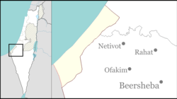
Kfar Yam
Appearance
This Since all references are dead links the article needs additional citations for verification. (August 2014) |
Kfar Yam
| |
|---|---|
| Coordinates: 31°21′09″N 34°15′31″E / 31.35250°N 34.25861°E | |
| Country | Israel |
| Founded | 1983 |
Kfar Yam (Template:Lang-he) was a small outpost and one of the Gaza Strip Israeli Settlements abandoned in Israel's 2005 disengagement plan.
History
Kfar Yam was a non-religious community established in 1983, and had a population of 10 (4 families).[1] The community was established on abandoned land which used to be a holiday village for officers of the occupying Egyptian Army.[2]
References
Wikimedia Commons has media related to Kfar Yam.

