
Kintampo waterfalls
| Kintampo | |
|---|---|
 | |
 | |
 | |
| Location | Kintampo, Ghana |
| Type | Multi-step |
| Number of drops | 3 |
| Longest drop | 25 metres (82 ft) |
| Watercourse | Pumpum |
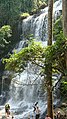
Kintampo waterfalls is one of the highest waterfalls in Ghana. Also known as Sanders Falls during the colonial days, it is located on the Pumpum river, a tributary of the Black Volta, about 4 kilometres (2.5 mi) north of Kintampo municipality, on the Kumasi-Tamale road. This waterfall, one of the main natural attractions in the area, is hidden in the forest and it is formed by 3 main drops where the longest drop measures 25 metres (82 ft) in height, and, after a number of steps and cascades, the river falls about 70 metres (230 ft).[1][2][3][4]
Gallery
-
 Main drop (front view)
 -
 Main drop (lateral view)
 -
 Staircase leading to the waterfall


References
- ^ "Kintampo Waterfall". ghana.photographers-resource.com.
- ^ "Kintampo Waterfalls". Ghana Tourism Authority.
- ^ "Kintampo Waterfalls". Wildlife and Nature Reserves. ghanaexpeditions.com.
- ^ "tourism attractions". about this district. Kintampo North Municipal Assembly.
External links
 Media related to Kintampo Waterfalls at Wikimedia Commons
This Ghana location article is a stub. You can help Wikipedia by expanding it. |