Koindu
Koindu
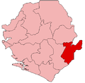
Koindu, Kailahun District | |
|---|---|
| Coordinates: 8°27′43″N 10°20′18″W / 8.46194°N 10.33833°W | |
| Country | |
| Province | Eastern Province |
| District | Kailahun District |
| Chiefdom | Kissi Teng |
| Time zone | UTC-5 (GMT) |
Koindu[2] is a town in Kailahun District in the Eastern Province of Sierra Leone. Koindu should not be confused with Koidu, which is a major diamond mining town in Kono District[3] and market center.[4] The population of Koindu is estimated at 16,751. Koindu lies approximately 63 miles from Kenema and about 230 miles east of Freetown.
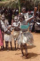
The population of Koindu is largely from the Kissi ethnic group.[5]
Picture
Notable people
- Sahr Senesie, German football star
- Dr. Paul T. Yillia, research scholar at the International Institute for Applied Systems Analysis, Austria
Notes
- ^ [1]
- ^ Koindu (Approved) at GEOnet Names Server, United States National Geospatial-Intelligence Agency
- ^ Hynes, Bridget. Children of the Borderlands: Young Soldiers in the Reproduction of Warfare. Ann Arbor, Michigan: Proquest. p. 179. dissertation at Conflict Resolution Institute, University of Denver.
- ^ Trillo. Richard (2008). The Rough Guide to West Africa. London: Penguin. pp. 554–555. ISBN 978-1-4053-8070-6.
- ^ Bah, M. Alpha (1998). Fulbe presence in Sierra Leone: a case history of twentieth-century migration and settlement among the Kissi of Koindu. New York: P. Lang. ISBN 978-0-8204-2180-3.


