
Kolossi Castle
| Kolossi Castle | |
|---|---|
 Kolossi Castle | |
 | |
| General information | |
| Architectural style | Stronghold |
| Town or city | Limassol |
| Country | Cyprus |
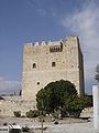
Kolossi Castle is a stronghold a few kilometers outside the city of Limassol on the island of Cyprus. It held great strategic importance and contained production of sugar, one of Cyprus' main exports in the Middle Ages. The original castle was possibly built in 1210 by Frankish military when the land of Kolossi was given by King Hugh III to the Knights of the Order of St John of Jerusalem (Hospitallers) (see also Commandaria), and the present castle was built in 1454 by the Hospitallers. Dwellers in the castle include the Templars and the already mentioned Hospitallers.
Gallery
-
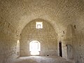 A hall inside the castle
 -
 Lusignan escutcheon on the eastern wall
 -


This article about a building or structure in Cyprus is a stub. You can help Wikipedia by expanding it. |