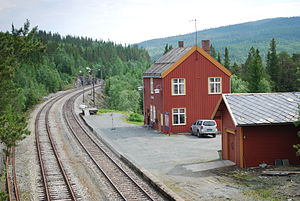
Kopperå Station
Appearance
Kopperå | |
|---|---|
 | |
| General information | |
| Location | Kopperå, Meråker Norway |
| Coordinates | 63°23′31″N 11°50′54″E / 63.392021°N 11.848412°E |
| Elevation | 328.5 metres (1,078 ft) |
| Operated by | Norwegian State Railways |
| Line(s) | Meråker Line |
| Distance | 88.30 kilometres (54.87 mi) |
| Platforms | 1 |
| History | |
| Opened | 1 April 1899 |
Kopperå Station (Template:Lang-no) is a railway station on the Meråker Line in the village of Kopperå in the municipality of Meråker in Nord-Trøndelag county, Norway. The station was opened on 1 April 1899 as Kopperaasen. It was renamed Kopperåen in April 1924. It received the current name on 1 September 1925.[1]
The station is served twice a day in each direction by Mittnabotåget operated by the Norwegian State Railways. It is located 88 kilometres (55 mi) from Trondheim and sits at an elevation of 328.5 metres (1,078 ft) above sea level.[2]
References
- ^ "Kopperå" (in Norwegian). Norske Jernbaneklubb. Retrieved 2011-05-04.
- ^ "Kopperå stasjon" (in Norwegian). Jernbaneverket. Retrieved 2011-05-04.
External links
| Preceding station | Following station | |||
|---|---|---|---|---|
| Meråker | Meråker Line | Storlien | ||
| Preceding station | Regional trains | Following station | ||
