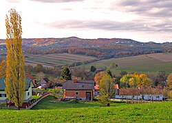
Kramarovci
Appearance
Kramarovci | |
|---|---|
 | |
| Coordinates: 46°48′34.43″N 16°0′5.88″E / 46.8095639°N 16.0016333°E | |
| Country | |
| Traditional region | Prekmurje |
| Statistical region | Mura |
| Municipality | Rogašovci |
| Area | |
• Total | 1.94 km2 (0.75 sq mi) |
| Elevation | 277.6 m (910.8 ft) |
| Population (2002) | |
• Total | 60 |
| [1] | |
Kramarovci (pronounced [ˈkɾaːmaɾɔu̯tsi]; Template:Lang-hu,[2] Template:Lang-de,[3][4] Prekmurje Slovene: Kromarovci[citation needed]) is a small village in the Municipality of Rogašovci in the Prekmurje region of northeastern Slovenia, right on the border with Austria.[5]
There is a small chapel in the centre of the settlement. It was built in the early 20th century and has a belfry attached to it.[6]
References
- ^ Statistical Office of the Republic of Slovenia
- ^ Vengušt, Jernej. 1919. Seznamek prekmurskih občin (krajev) z označbo pošte in zemljevidom. Radgona, p. 8.
- ^ Balažic, Janez. 1996. Völker an der Mur. Murska Sobota: Pokrajinski muzej, p. 231.
- ^ Killer, Kurt. 2001. Lithokarten aus Österreich: mit besonderer Berücksichtigung der Steiermark. Graz: author, p. 187.
- ^ Rogašovci municipal site
- ^ Slovenian Ministry of Culture register of national heritage reference number 12287


