
Lagos Lagoon
| Lagos Lagoon [NIGERIA] | |
|---|---|
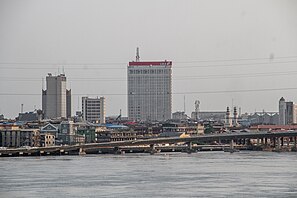
 Lagos Lagoon in 2007 | |
| Location | Lagos State, Nigeria |
| Coordinates | 6°27′N 3°23′E / 6.450°N 3.383°E |
| Type | lagoon |
| Basin countries | Nigeria |
| Max. length | 50 km |
| Max. width | 13 km |
| Surface area | 6,354.7 km² |
| Surface elevation | 0 m |
| Islands | Lagos Island, Victoria Island |
| Settlements | Lagos |
Lagos Lagoon is a lagoon sharing its name with the city of Lagos, Nigeria, the largest city in Africa, which lies on its south-western side. The name is Portuguese, and means 'lakes' in the Portuguese language so 'Lagos Lagoon' is an example of a tautological place name.
Physical Characteristics
The lagoon is more than 50 km long and 3 to 13 km wide, separated from the Atlantic Ocean by a long sand spit 2 to 5 km wide, which has swampy margins on the lagoon side. Its surface area is approximately 6,354.7 km².[1] The lagoon is fairly shallow and is not plied by ocean-going ships, but by smaller barges and boats.
The lagoon receives the discharge of the Ogun River and the Osun River.
Geography

Lagos Lagoon empties into the Atlantic via Lagos Harbour, a main channel through the heart of the city, 0.5 km to 1 km wide and 10 km long. The principal ocean port of Lagos is located at Apapa in a broad western branch off the main channel of the harbour.
Another branch off the main channel, narrower and longer, separates Lagos Island from Victoria Island, the broad sand spit which forms the coastline.
The city spreads along more than 30 km of the lagoon's south-western and western shoreline. Pollution by urban and industrial waste is a major problem as a large amount of wastewater is released into the lagoon daily. The 11-km-long Third Mainland Bridge was built off the western shore to by-pass congested mainland suburbs.
To its north-east the lagoon is connected by a channel passing south of the town of Epe to the Lekki Lagoon. Narrow winding channels connect the system through a broad band of coastal swamps and rivers, as far away as Sapele, 250 km to the east.
The areas west of Lagos Lagoon are not well provided with roads and many communities there traditionally relied on water transport.
Mini Photo Gallery
- Lagos Lagoon
-
 Lagos Lagoon, Nigeria
 -
 Lagos Lagoon, Nigeria
 -
 Lagos Lagoon
 -
 Lagos Lagoon


Notes
- ^ Lagos Lagoon Coastal Profile: Information Database For Planning Theory, by Obafemi McArthur Okusipe, Department of Urban and Regional Planning, University of Lagos - Accessed September 22, 2008