Laza, Qusar
Appearance
41°17′42″N 48°06′22″E / 41.29500°N 48.10611°E
Laza | |
|---|---|
 | |
| Coordinates: 41°17′42″N 48°06′22″E / 41.29500°N 48.10611°E | |
| Country | |
| Rayon | Qusar |
| Municipality | Kuzun |
| Time zone | UTC+4 (AZT) |
| • Summer (DST) | UTC+5 (AZT) |
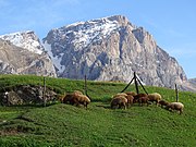
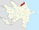
Laza is a village in the Qusar Rayon of Azerbaijan. The village forms part of the municipality of Kuzun.[1]
About
[edit]Laza village is located 1300 m above sea level at the foot of the Mount Shahdagh in the north-east of the Greater Caucasus. The village is well known with its numerous waterfalls.[2]
There is a historical monument – a 300-year-old mosque in the village.[3]
Ethnic Lezgins live in the village. There are 28 houses in the village of Laza where nearly 170 people live. The main occupation of the residents is cattle-breeding. People cultivate potatoes and cabbage.[2][3]
Gallery
[edit]-
Laza mosque
-
Laza fall
-
Laza village
References
[edit]- ^ "Belediyye Informasiya Sistemi" (in Azerbaijani). Archived from the original on September 24, 2008.
- ^ a b "Azərbaycanın şəlalələr diyarı - Ləzə". azertag.az (in Azerbaijani). Archived from the original on 2019-06-28. Retrieved 2019-06-28.
- ^ a b "Qusarın 8 maraqlı görməli yeri". azertag.az (in Azerbaijani). Archived from the original on 2019-06-28. Retrieved 2019-06-28.
External links
[edit]- Laza, Qusar at GEOnet Names Server
 Media related to Laza, Qusar at Wikimedia Commons


