Jump to content

Locks on the Canal du Midi

From Wikipedia, the free encyclopedia

This is an old revision of this page, as edited by Corvins (talk | contribs) at 12:10, 17 April 2016 (+ pictures). The present address (URL) is a permanent link to this revision, which may differ significantly from the current revision.

Lock sign on the Canal du Midi

There are 91 working locks on the Canal du Midi along its 240-kilometre (150 mi) course from the Bassin du Thau on the Mediterranean coast to the junction with the Canal lateral a la Garonne in Toulouse. There are a further 13 locks on the 37-kilometre (23 mi) La Nouvelle branch which runs through Narbonne to the Mediterranean at Port-la-Nouvelle.[1] The locks are all under the management of the French navigation authority, Voies navigables de France.

Construction

Typical lock keeper's house on the Canal du Midi

The Canal du Midi was built between 1666 and 1681 by Pierre-Paul Riquet to provide an inland water route through Southern France between the Atlantic at Bordeaux and the Mediterranean at Sète via the Garonne. The first design for the locks on the canal was a rectangular shape however due to a collapse of a side-wall early in the building program (exactly which lock is not recorded), Riquet modified his plans and rebuilt both existing and new locks with an ovoid chamber. They were typically 11m wide at the midpoint and 6m at the gates with an overall length of 30.5m.[1] Riquet also restricted the maximum rise to 2.9m so whereas previously he would have built one deep lock he instead used intermediate gates creating double, triple and sometimes quadruple chambers. During the Canal du Midi modernisation program of the 1970s several of these multiple chambers were converted into single "deep" locks with concrete side walls.

The lock gates were originally made of oak in the traditional mitre pattern with balance beams and each gate had a single large wooden sluice drawn up by a vertical screw.[1] The introduction of electric and hydraulic systems for both the lifting of the sluices and the opening of the gates has seen the removal of the balance beams and modern gates are of metal construction.

At each lock there is a double-fronted two-storey lock keeper's house upon which is fixed either a cast iron or a masonry sign showing the name of the lock and the name and distance to the adjacent locks in each direction. The locks are still operated by lock keepers and passage is only possible when they are in attendance however on La Nouvelle branch operation by boaters is allowed. The locks are open every day except 1 January, 11 November and 25 December, from 08:00 until 17:30 out of season and 08:00 until 19:00 in the summer peak; all locks are closed 12:30 – 13:30 for lunch.[2]

Profile

At its western end, Toulouse, the canal is at an altitude of 132 metres (433 ft) and climbs to 193 metres (633 ft) at its summit level between Ocean Lock and Mediterranee Lock west of Castelnaudary before dropping down to sea level at Sète.[3]
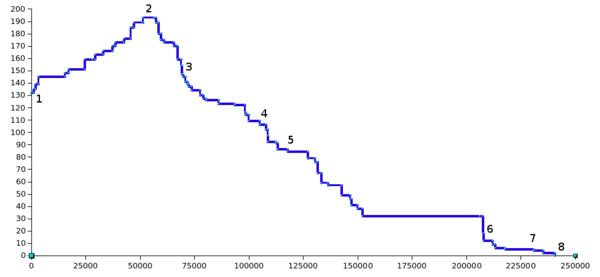
Profile of the Canal du Midi (distances in metres from Toulouse and height in metres above sea-level)

The graph shows the profile of the Canal du Midi from Toulouse (1), through the summit of the canal at Seuil de Naurouze (2), Castelnaudary (3), then Carcassonne (4) and Trèbes (5). The channel continues to Béziers just after Fonsérannes Lock (6), and then on to Agde (7) before flowing in to the Bassin de Thau at Sète (8).

At 193 metres (633 ft), Naurouze is the highest point of the canal with a drop of 57.18 metres (187.6 ft) between the summit and Toulouse and 189.43 metres (621.5 ft) between the summit and Sète. The longest pound is 53.49 kilometres (33.24 mi) between Argens Lock (Aude) and the Fonsérannes Lock (Hérault) while the shortest reach is 250 metres (820 ft) between two locks at Fresquel.[4]

Locks

The following list numbers the locks from the Canal lateral a la Garonne in the west to the Bassin du Thau in the east. Staircase locks are listed as a single entity but the number of individual chambers in the flight is noted. Travelling west to east from Toulouse to Sète the locks numbered 1–18 are ascending and 19–86 are descending.[B]

Locks in the Canal du Midi
Lock
number[A]
Lock name Coordinates
(links to maps
and satellite images)
Number of
chambers
Distance
from Toulouse
(km)
Image Altitude
(metres)[3]
1 Béarnais Lock 43°36′44″N 1°25′32″E / 43.612142°N 1.425618°E / 43.612142; 1.425618 (Béarnais Lock) 1 1.1 135m
2 Minimes Lock 43°36′57″N 1°26′10″E / 43.615829°N 1.435984°E / 43.615829; 1.435984 (Minimes Lock) 1 2 139m
3 Bayard Lock 43°36′39″N 1°27′11″E / 43.610786°N 1.453021°E / 43.610786; 1.453021 (Bayard Lock) 1 3.6 145m
4 Castanet Lock 43°31′25″N 1°31′07″E / 43.523582°N 1.518711°E / 43.523582; 1.518711 (Castanet Lock) 1 15.7 148m
5 Vic Lock 43°30′39″N 1°31′02″E / 43.51095°N 1.517295°E / 43.51095; 1.517295 (Vic Lock) 1 17.4 151m
6 Montgiscard Lock 43°27′47″N 1°34′14″E / 43.463105°N 1.570518°E / 43.463105; 1.570518 (Montgiscard Lock) 1 24.9 155m
7 Aygues-Vives Lock 43°26′48″N 1°35′57″E / 43.446677°N 1.599266°E / 43.446677; 1.599266 (Aygues-Vives Lock) 1 28.1 159m
8 - 9 Sanglier Lock 43°26′23″N 1°36′45″E / 43.43961°N 1.61242°E / 43.43961; 1.61242 (Sanglier Lock) 2 29.6 163m
10 Négra Lock 43°25′07″N 1°38′28″E / 43.418499°N 1.641028°E / 43.418499; 1.641028 (Négra Lock) 1 33.3 166m
11 - 12 Laval Lock 43°23′55″N 1°40′46″E / 43.39853°N 1.679504°E / 43.39853; 1.679504 (Laval Lock) 2 37.5 170m
13 Gardouch Lock 43°23′30″N 1°41′30″E / 43.391631°N 1.691761°E / 43.391631; 1.691761 (Gardouch Lock) 1 38.9 173m
14 Renneville Lock 43°22′59″N 1°43′39″E / 43.383070°N 1.727608°E / 43.383070; 1.727608 (Renneville Lock) 1 43.0 176m
15 - 16 Encassan Lock 43°22′08″N 1°45′22″E / 43.368891°N 1.756014°E / 43.368891; 1.756014 (Encassan Lock) 2 45.9 185m
17 Emborrel Lock 43°21′47″N 1°46′23″E / 43.363113°N 1.773073°E / 43.363113; 1.773073 (Emborrel Lock) 1 47.5 189m
18 Océan Lock 43°21′19″N 1°49′05″E / 43.355309°N 1.818083°E / 43.355309; 1.818083 (Océan Lock) 1 51.6 193m
51.5 Summit (Seuil de Naurouze) 43°21′19″N 1°49′05″E / 43.355309°N 1.818083°E / 43.355309; 1.818083 (Summit) 52 193m
19 Méditerranée Lock 43°19′49″N 1°51′42″E / 43.330160°N 1.861777°E / 43.330160; 1.861777 (Méditerranée Lock) 1 56.6 193m
20-21 Roc Lock 43°19′43″N 1°52′14″E / 43.328685°N 1.870472°E / 43.328685; 1.870472 (Roc Lock) 2 57.5 189m
22 -24 Laurens Lock 43°19′31″N 1°53′06″E / 43.325246°N 1.884968°E / 43.325246; 1.884968 (Laurens Lock) 3 58.7 180m
25 Domergue Lock 43°19′23″N 1°53′56″E / 43.323029°N 1.898843°E / 43.323029; 1.898843 (Domergue Lock) 1 59.7 175m
26 Laplanque Lock 43°19′15″N 1°54′49″E / 43.320900°N 1.913678°E / 43.320900; 1.913678 (Laplanque Lock) 1 60.9 173m
27 - 30 Saint-Roch Lock 43°18′43″N 1°57′40″E / 43.311834°N 1.961133°E / 43.311834; 1.961133 (Saint-Roch Lock) 4 65.4 170m
31 - 32 Gay Lock 43°18′19″N 1°58′39″E / 43.305225°N 1.977624°E / 43.305225; 1.977624 (Gay Lock) 2 67.1 159m
33 - 35 Vivier Lock 43°17′51″N 1°59′39″E / 43.297457°N 1.994101°E / 43.297457; 1.994101 (Vivier Lock) 3 68.7 154m
36 Guilhermin Lock 43°17′46″N 1°59′58″E / 43.296145°N 1.999405°E / 43.296145; 1.999405 (Guilhermin Lock) 1 69.1 147m
37 Saint-Sernin Lock 43°17′36″N 2°00′18″E / 43.29320°N 2.00505°E / 43.29320; 2.00505 (Saint-Sernin Lock) 1 69.7 145m
38 Guerre Lock 43°17′24″N 2°00′57″E / 43.290083°N 2.015755°E / 43.290083; 2.015755 (Guerre Lock) 1 70.6 141m
39 Peyruque Lock 43°17′12″N 2°01′42″E / 43.286689°N 2.028383°E / 43.286689; 2.028383 (Peyruque Lock) 1 71.7 139m
40 Criminelle Lock 43°17′07″N 2°02′03″E / 43.28532°N 2.03417°E / 43.28532; 2.03417 (Criminelle Lock) 1 72.2 137m
41 Tréboul Lock 43°16′49″N 2°02′59″E / 43.280219°N 2.049757°E / 43.280219; 2.049757 (Tréboul Lock) 1 73.6 134m
42 Villepinte Lock 43°16′26″N 2°05′39″E / 43.274°N 2.09412°E / 43.274; 2.09412 (Villepinte Lock) 1 77.4 130m
43 Sauzens Lock 43°15′56″N 2°06′35″E / 43.26544°N 2.10980°E / 43.26544; 2.10980 (Sauzens Lock) 1 79 127m
44 Bram Lock 43°15′30″N 2°07′12″E / 43.25830°N 2.12011°E / 43.25830; 2.12011 (Bram Lock) 1 80.3 126m
45 Béteille Lock 43°14′08″N 2°10′48″E / 43.235532°N 2.180042°E / 43.235532; 2.180042 (Béteille Lock) 1 85.9 123m
46 Villeséquelande Lock 43°14′05″N 2°14′45″E / 43.234812°N 2.245796°E / 43.234812; 2.245796 (Villeséquelande Lock) 1 93.4 122m
47 - 48 Lalande Lock 43°14′21″N 2°17′09″E / 43.239241°N 2.285786°E / 43.239241; 2.285786 (Lalande Lock) 2 98.2 116m
49 Herminis Lock 43°14′14″N 2°17′18″E / 43.237300°N 2.288296°E / 43.237300; 2.288296 (Herminis Lock) 1 98.5 114m
50 Ladouce Lock 43°13′46″N 2°18′04″E / 43.229506°N 2.301099°E / 43.229506; 2.301099 (Ladouce Lock) 1 99.9 109m
51 Carcassonne Lock 43°13′03″N 2°21′06″E / 43.217409°N 2.351585°E / 43.217409; 2.351585 (Carcassonne Lock) 1 105.5 106m
52 Saint-Jean Lock 43°13′56″N 2°22′30″E / 43.232295°N 2.375039°E / 43.232295; 2.375039 (Saint-Jean Lock) 1 108.0 102m
53 - 54 Fresquel Double Lock 43°14′18″N 2°22′29″E / 43.238394°N 2.374646°E / 43.238394; 2.374646 (Fresquel Double Lock) 2 108.8 97m
55 Fresquel Single Lock 43°14′27″N 2°22′47″E / 43.240847°N 2.379621°E / 43.240847; 2.379621 (Fresquel Single Lock) 1 109.0 92m
56 Evêque Lock 43°14′08″N 2°24′48″E / 43.235572°N 2.413292°E / 43.235572; 2.413292 (Evêque Lock) 1 112.6 91m
57 Villedubert Lock 43°13′47″N 2°24′48″E / 43.229698°N 2.413303°E / 43.229698; 2.413303 (Villedubert Lock) 1 113.4 86m
58 - 60 Trèbes Lock 43°12′25″N 2°26′57″E / 43.206848°N 2.449276°E / 43.206848; 2.449276 (Trèbes Lock) 3 118 84m
61 Marseillette Lock 43°12′20″N 2°32′59″E / 43.205563°N 2.549688°E / 43.205563; 2.549688 (Marseillette Lock) 1 127.2 79m
62 - 64 Fonfile Lock 43°12′39″N 2°35′06″E / 43.210825°N 2.584946°E / 43.210825; 2.584946 (Fonfile Lock) 3 130.4 76m
65 - 66 Saint-Martin Lock 43°13′02″N 2°35′49″E / 43.217296°N 2.596895°E / 43.217296; 2.596895 (Saint-Martin Lock) 2 131.6 67m
67 - 68 Aiguille Lock 43°13′47″N 2°36′21″E / 43.229629°N 2.605914°E / 43.229629; 2.605914 (Aiguille Lock) 2 133.4 59m
69 - 70 Puichéric Lock 43°13′51″N 2°38′18″E / 43.230855°N 2.638368°E / 43.230855; 2.638368 (Puichéric Lock) 2 136.4 57m
71 Jouarres Lock 43°15′43″N 2°41′11″E / 43.261912°N 2.686302°E / 43.261912; 2.686302 (Jouarres Lock) 1 142.7 49m
72 Homps Lock 43°16′12″N 2°43′47″E / 43.269874°N 2.729844°E / 43.269874; 2.729844 (Homps Lock) 1 146.4 46m
73 - 74 Ognon Lock 43°16′11″N 2°44′19″E / 43.269768°N 2.738583°E / 43.269768; 2.738583 (Ognon Lock) 2 147.1 41m
75 - 76 Pechlaurier Lock 43°15′01″N 2°45′25″E / 43.25023°N 2.757046°E / 43.25023; 2.757046 (Pechlaurier Lock) 2 149.8 38m
77 Argens Lock 43°14′23″N 2°46′45″E / 43.239757°N 2.779187°E / 43.239757; 2.779187 (Argens Lock) 1 152.3 32m
78[B] Fonserannes Lock 43°19′50″N 3°11′59″E / 43.330556°N 3.199722°E / 43.330556; 3.199722 (Fonserannes Locks) 6 (+2 unused) 206.6 32m
79 Orb Lock 43°20′07″N 3°12′56″E / 43.335256°N 3.215434°E / 43.335256; 3.215434 (Orb Lock) 1 208.0 12m
80 Béziers Lock 43°20′00″N 3°13′17″E / 43.333429°N 3.221367°E / 43.333429; 3.221367 (Béziers Lock) 1 208.4
81 Ariège Lock 43°19′21″N 3°15′56″E / 43.322535°N 3.265474°E / 43.322535; 3.265474 (Ariège Lock) 1 212.5 9m
82 Villeneuve Lock 43°19′04″N 3°16′50″E / 43.317681°N 3.280495°E / 43.317681; 3.280495 (Villeneuve Lock) 1 213.8 6m
83 Portiragnes Lock 43°18′17″N 3°19′45″E / 43.304761°N 3.329285°E / 43.304761; 3.329285 (Portiragnes Lock) 1 218.3 5m
84 Agde Round Lock[C] 43°19′13″N 3°28′03″E / 43.320253°N 3.467624°E / 43.320253; 3.467624 (Agde Round Lock) 1 231.4 4m
85 Prades Lock 43°19′33″N 3°28′40″E / 43.325967°N 3.477808°E / 43.325967; 3.477808 (Prades Lock) 1 232.9 3m
86 Bagnas Lock 43°18′52″N 3°29′56″E / 43.314319°N 3.498874°E / 43.314319; 3.498874 (Bagnas Lock) 1 235.3 2m

See also

Notes

A Lock numbers are as given in the appendix of the 1994 edition From Sea to Sea by L.T.C. Rolt
B The flight at Fonserannes was "replaced" by a water slope in 1984 hence the single "lock number". However, the slope has never worked and the 6 flight staircase remains the only way to pass through meaning that there are 91 locks but only 86 numbers.
C Chamber has three sets of gates, the third being the junction with the branch descente dans l'Hérault

References

  1. ^ a b c Rolt, L. T. C. (1973). From Sea to Sea: An Illustrated History of the Canal du Midi. Allen Lane. ISBN 0713904712. {{cite book}}: Cite has empty unknown parameter: |coauthors= (help)
  2. ^ "Les horaires de navigation". Voies navigables de France website. Retrieved 2008-10-25.
  3. ^ a b "Toutes les Écluses du Canal du Midi". canaldumidi.com. Retrieved 2008-10-25.
  4. ^ René Gast, Le canal du Midi et les voies navigables de l'Atlantique à la Méditerranée, éditions Ouest-France, 2000, ISBN 2-7373-2475-0, p. 22