
Lough Finn
| Lough Finn Loch Finne | |
|---|---|
 | |
| Location | County Donegal, Ireland |
| Coordinates | 54°51′50″N 8°07′52″W / 54.864°N 8.131°W |
| Basin countries | Ireland, Northern Ireland |
| Max. length | approx. 5 km (3.1 mi) |
| Max. width | approx. 0.5 km (0.3 mi) |
| Surface area | approx. 2.5 km2 (0.97 sq mi) |
| Surface elevation | 169 m (554 ft) |
| Settlements | Fintown |
Lough Finn (Irish: Loch Finne) is a freshwater lough (lake) in County Donegal, Ireland. The lough, along with its neighbouring village of Fintown, was named after a mythological woman, Finngeal, who drowned in the lake after attempting to save her wounded brother Feargamhain.[1] The water from Lough Finn outflows into the River Finn.
Gallery
-
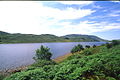 The lough, as seen from the nearby heritage railway.
 -
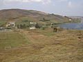 Looking down on the SW end of Lough Finn.
 -
 Fintown Railway on trackbed of CDR County Donegal Railways Joint Committee, next to Lough Finn with a train in the platform at Fintown station.


.jpg)
Fintown Railway | ||||||||||||||||||||||||||||||||||||||||||||||||||||||||
|---|---|---|---|---|---|---|---|---|---|---|---|---|---|---|---|---|---|---|---|---|---|---|---|---|---|---|---|---|---|---|---|---|---|---|---|---|---|---|---|---|---|---|---|---|---|---|---|---|---|---|---|---|---|---|---|---|
| ||||||||||||||||||||||||||||||||||||||||||||||||||||||||
See also
References
- ^ http://www.dun-na-ngall.com/fintown.html County Donegal on the Net