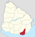
Maldonado, Uruguay
Maldonado | |
|---|---|
Capital city | |
| Country | |
| Department | Maldonado Department |
| Founded | 1755 |
| Founded by | Joaquín de Viana |
| Government | |
| • Mayor(Alcalde) | Dina Fernández Chaves (Partido Nacional) |
| Population (2011) | |
| • Total | 62,590 |
| • Demonym | Fernandino |
| Time zone | UTC -3 |
| Postal code | 20000 |
| Dial plan | +598 42 (+6 digits) |
| Climate | Cfb |
Maldonado is the capital of Maldonado Department of Uruguay. As of the census of 2011, it is the seventh most populated city of the country.
Maldonado is also the name of the municipality to which the city belongs. It includes the following zones: Maldonado, Punta Ballena, Portezuelo, Barrio Hipódromo, Canteras de Marelli, Los Ceibos, Abra de Perdomo, Laguna del Diario, El Placer, Cantegril, Maldonado Nuevo, Cerro Pelado, San Francisco, San Fernando, Estación, Leonel, Perlita, El Molino, and Biarritz.
Location and geography
It is located on Route 39 and shares borders with Punta del Este to the south, Pinares - Las Delicias to the south and to the east and suburb La Sonrisa to the north. Together they all form a unified metropolitan area. The next city to the north is San Carlos, only 13 kilometres (8.1 mi) away on Route 39.
East of the city flows the stream Arroyo Maldonado.
History
Maldonado was founded on 19 October 1755 at the initiative of the Governor of Montevideo Joaquin de Viana. It was firmly established by the arrival of 104 permanent settlers in 1757. Its original name was "Maldonado", but, years later, its name was changed to "San Fernando de Maldonado", in honor of King Ferdinand VI of Spain. It had acquired the status of "ciudad" (city) before the independence of Uruguay.[1]
Population
In 2011 the city of Maldonado had a population of 62,590.[2] According to the Intendencia Departamnetal de Maldonado, the municipality of Maldonado has a population of 105,000.[3]

| Year | Population |
|---|---|
| 1908 | 4,431 |
| 1963 | 15,005 |
| 1975 | 22,762 |
| 1985 | 33,535 |
| 1996 | 48,936 |
| 2004 | 54,603 |
| 2011 | 62,590 |
Source: Instituto Nacional de Estadística de Uruguay[1]
Main sights
Remarkable sights in Maldonado include:
- San Fernando de Maldonado Cathedral, a neoclassic cathedral begun in 1801 and completed in 1895
- Cuartel de Dragones (The Dragoons' Barracks), a Spanish garrison begun in 1771 and completed in 1797
- Torre del Vigia (meaning "tower of vigilance" or, more simply, "watchtower"), built in 1800 under the direction of Rafael Pérez del Puerto; its function was to inform the authorities of the entrance in Buenos Aires of the approach of any ship to the Río de la Plata
- El Puente de la Barra,[4] a stressed ribbon bridge, where the roadbed swoops up, down, and back up and down once more, demonstrating an exceptional economy of material[5]
- Casapueblo hotel
Places of worship
- Cathedral of St. Ferdinand (Roman Catholic)
- Church of Our Lady of the Remedies (Roman Catholic)
- Church of Our Lady of the Thirty-Three (Roman Catholic)
Notable residents
- Alberto Abdala (1920-1986), Vice President of Uruguay from 1967 to 1972
- Johnny Aquino (1978- ), Association Football midfielder for Sarmiento de Junín [6]
- Martín Campaña (1989- ), goalkeeper for Cerro Largo FC[7]
- Fernando Clavijo (1956- ), retired soccer player for the Colorado Rapids
References
- ^ a b "Statistics of urban localities (1908–2004)" (PDF). INE. 2012. Retrieved 7 September 2012.
- ^ "Censos 2011 Maldonado (needs flash plugin)". INE. 2012. Retrieved 25 August 2012.
- ^ "Presupuesto-2011-2015". Intendencia Departamnetal de Maldonado. 2012. Retrieved 11 September 2012.
- ^ Puente de la Barra de Maldonado at Structurae. Retrieved 2009-12-07. 34°54′39″S 54°52′22″W / 34.910904°S 54.872745°W
- ^ Puente de la Barra de Maldonado
- ^ http://www.bdfa.com.ar/jugadores-JOHNNY-EDUARDO-AQUINO-7709.html
- ^ http://www.soccerway.com/players/martin-campana/91568/
See also
External links
- Many pictures of Maldonado, Punta del Este, Punta Ballena, Casapueblo, José Ignacio, Piriápolis, La Barra, Sierra De Las Animas
- The Maldonado Portal
- Hotels in Punta del Este, Maldonado
- INE map of Maldonado, Villa Delia, La Sonrisa, Cerro Pelado, Los Aromos and Pinares-Las Delicias
- Map of the city of Maldonado by the Intendencia


