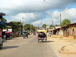
Manantay District
Appearance
Manantay | |
|---|---|
 | |
| Country | |
| Region | Ucayali |
| Province | Coronel Portillo |
| Founded | June 2, 2006 |
| Capital | San Fernando |
| Time zone | UTC-5 (PET) |
| UBIGEO | 250107 |
Manantay District is one of the seven districts of the province Coronel Portillo in Peru.[1]
References
- ^ Template:Es icon Instituto Nacional de Estadística e Informática. Banco de Información Digital Archived 2008-04-23 at the Wayback Machine. Retrieved April 9, 2008.
8°26′S 74°33′W / 8.433°S 74.550°W
