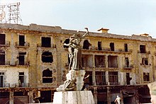
Martyrs' Square, Beirut

This article needs additional citations for verification. (July 2015) |
33°53′46.86″N 35°30′25.31″E / 33.8963500°N 35.5070306°E

Martyrs' Square (Template:Lang-ar Sahet el Shouhada, Template:Lang-fr) is a square in the heart of downtown Beirut, Lebanon.
Overview
In 1931, the historic square took its name to commemorate the martyrs executed there under Ottoman rule. In the 1950s the square became a popular venue for cinemas and coffee-houses. During the Lebanese Civil War, it formed the demarcation line that divided the city in half.
Construction
Initially Sahat al-Burj, the square underwent a lot of transformations until 1931, where it took the name of Martyrs' Square in commemoration of the martyrs executed there under Ottoman rule. The Municipality of Beirut modernized the square in 1878 as the main meeting place of the city. Beshara Effendi designed a garden with fountain and kiosks, overlooked by the Petit Serail - the seat of Beirut’s governor general – as well as public buildings and souks. In 1950, the Petit Serail was demolished. The new Rivoli cinema blocked the link between the square and the harbor. Martyrs’ Square became Beirut’s bus and taxi terminus and a popular venue for cinemas, coffee-houses, modest hotels and the red-light district. During the Civil War (1975-1990), Martyrs’ Square formed the demarcation line that divided the city in half. In 2005, an international competition was launched for the design of a new square with its axis open to the sea, reestablishing Martyrs’ Square as Beirut’s premier public space and heart of the capital.
History
Martyrs’ Square originated as an open space (maydan) beyond the city wall. The ancient watchtower of Burj al-Kashef marked its outer limit, and gave the square its first and still surviving name, Sahat al-Burj (Tower Square). In 1773, a Russian cannon placed near the Burj caused the square’s name to be changed to ‘Place du Canon’ (Cannon Square). It became ‘Place des Canons’ (Cannons Square) in 1860, when the initial Russian cannon was replaced by cannons from the French fleet. Named ‘Hamidiyyeh Square’ in 1884 to honor Sultan Abdul Hamid II, it became ‘Union Square’ and then ‘Freedom Square’ with the advent of the Young Turks revolution of 1908. In 1931, the square took the name it still officially bears today, Martyrs’ Square, to commemorate the martyrs executed there under Ottoman rule. First enclosed as a formal urban space in the 1860s, the Municipality of Beirut modernized the square in 1878 as the main meeting place of the city. Beshara Effendi designed a garden with fountain and kiosks, overlooked by the Petit Serail - the seat of Beirut’s governor general – as well as public buildings and souks. The tramway, built in 1906, placed the square at the center of Beirut’s transport network. During the early years of the French Mandate, the Duraffourd and subsequent Danger Plans created the ‘Place de l’Etoile’ (Etoile Square). They proposed the demolition of the Petit Serail to open Martyrs’ Square to the sea, an ambition that was foiled. The square was neglected and Etoile Square became the geographic and administrative center of the capital. In 1950, the Petit Serail was demolished. The new Rivoli cinema blocked the link between the square and the harbor. Martyrs’ Square became Beirut’s bus and taxi terminus and a popular venue for cinemas, coffee-houses, modest hotels and the red-light district. During the Lebanese Civil War (1975-1990), Martyrs’ Square formed the demarcation line that divided the city in half. In 2005, an international competition was launched for the design of a new square with its axis open to the sea, reestablishing Martyrs’ Square as Beirut’s premier public space and heart of the capital.
Timeline
1773: Initially Sahat al-Burj, it became Place du canon, after the Russian cannon that was placed on the square.
1860: Renamed Place des canons after the Russian cannon was replaced by Cannons from the French fleet.
1878: Municipality of Beirut modernized the square as the main meeting place of the city.
1884: Named Hamidiyyeh Square in honor of Sultan Abdul Hamid II.
1906: The tramway was built and placed the square at the center of Beirut's transport network.
1908: Named Freedom Square following the advent of the Young Turks revolution.
1931: The square took the name of Martyrs' Square in commemoration of the martyrs executed there under Ottoman rule.
1950: The demolition of the Petit Serail, which was earlier proposed during the early years of the French Mandate.
1975-1990: Civil war, Martyrs’ Square formed the demarcation line that divided the city in half.
2005: International competition was launched for the design of a new square.
See also
- Sultan Abdul Hamid II
- Municipality of Beirut
- Petit Serail
- French Mandate
- Etoile Square
- Place de l'Etoile
- Lebanese Civil War
References
{{Davie, May (2001) Beyrouth 1825-1975. Un siècle et demi d’urbanisme, Ordre des ingénieurs et des architectes, Beyrouth.
Kassir, Samir (2003) Histoire de Beyrouth, Fayard, Paris. ISBN 2-213-02980-6.
Sassine Farès et Tuéni, Ghassan (direction) (2003) El-Bourj. Place de la Liberté et Porte du Levant, Editions Dar an-Nahar, Beyrouth.}}
