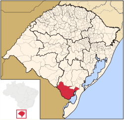
Microregion of Jaguarão
Appearance
Jaguarão | |
|---|---|
Microregion | |
 | |
| Country | Brazil |
| State | Rio Grande do Sul |
| Mesoregion | Sudeste Rio-Grandense |
| Municipalities | 3 |
| Area | |
• Total | 6,331.282 km2 (2,444.522 sq mi) |
The Jaguarão microregion (Template:Lang-pt-BR) is a microregion in the southern part of the state of Rio Grande do Sul, Brazil. Its total area is of 6,331.228 km².
Municipalities
The microregion consists of the following municipalities:[1]
References
- ^ Instituto Brasileiro de Geografia e Estatística, territorial division.
32°33′57″S 53°22′33″W / 32.56583°S 53.37583°W

