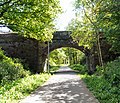
Middlewood Way

The Middlewood Way is a ten-mile (16 km) "linear park" in England, between Macclesfield (53°15′36″N 2°07′22″W / 53.2601°N 2.1229°W) and Rose Hill, Marple (53°23′42″N 2°04′39″W / 53.3950°N 2.0774°W), that was opened on 30 May 1985 by Dr David Bellamy.
Middlewood Way follows the route of the former Macclesfield, Bollington and Marple railway, which had operated between 1869 and 1970. The Middlewood Way serves the needs of walkers, dog walkers, cyclists, joggers and horse riders and plays host to a wide range of flora and fauna. It runs approximately parallel to the Macclesfield Canal and passes through Bollington and Higher Poynton. It can be reached by rail at Macclesfield, Middlewood and Rose Hill Marple.
The trail is rough and badly maintained in places and is probably best suited to those on foot or cyclists on mountain bikes and hybrids. The exception to this is the tarmac section between Bollington and Macclesfield, which is suitable for all cycles.
The trail forms part of National Cycle Network Route 55 from Ironbridge to Preston.
See also
Gallery
-
The old station at Higher Poynton.
-
The Middlewood Way in summer.
-
The Middlewood Way in winter.
External links
- Cheshire East Council Middlewood way page - includes map and guide
- Discovercheshire website (Middlewood Way page)


