Moll's Gap
| Moll's Gap | |
|---|---|
| Céim an Daimh | |
 Moll's Gap | |
| Elevation | 260 metres (850 feet) |
| Traversed by | N71 road |
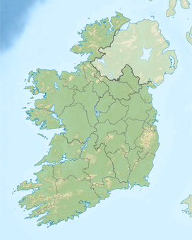
| Location | County Kerry, Ireland |
| Range | MacGillycuddy's Reeks |
| Coordinates | 51°56′17″N 9°39′27″W / 51.93818°N 9.657412°W |
| Topo map | OSI Discovery 78 |
Moll's Gap or Céim an Daimh (meaning, Gap of the Ox),[1] is a mountain pass on the N71 road from Kenmare to Killarney in County Kerry, Ireland.
Moll's Gap is on the Ring of Kerry route,[2] and offers views of the MacGillycuddy's Reeks mountains, and is a popular tourist location.[3] The rocks at Moll's gap are formed of Old Red Sandstone, which are small quartz grains laid down over 350 million years ago; unlike most of the Old Red Sandstone around Killarney which is stained red by iron oxide, the rock at Moll's gap is stained green by chlorite.[4] Moll's Gap is named after Moll Kissane, who ran a shebeen (an unlicensed public house) in the 1820s, while the road was under construction.[5][4]
Like the nearby Gap of Dunloe, Moll's Gap is an example of a "glacial breach", where a 500 metre deep glacier in the Black Valley broke through Moll's Gap 25,000 years ago during Ireland's last ice age.[6][4]
See also
[edit]References
[edit]- ^ "irish: Céim an Daimh, genitive: Chéim an Daimh, other english: Moll's Gap". Loganim.ie. Retrieved 16 December 2018.
- ^ "The top 5 road trips in Ireland". Irish Independent. 11 February 2016.
Just some of the highlights along the way are Gap of Dunloe, Bog Village, Rossbeigh Beach, Derrynane House, Staigue Fort, Moll's Gap, Ladies View, Torc Waterfall, The Blue Pool and Ross Castle.
- ^ "As rings go, this one rules them all". The Kerryman. 3 November 2010.
Just before Moll's Gap, visit Pancake Cottage (over 200 years old) for a homemade pancake – it also has a playground for under 14s. From Moll's Gap, the views are quite spectacular over Killarney National Park and the McGillycuddy Reeks. Take a ramble into the awesome Black Valley and be prepared for the wow factor the deeper in you venture.
- ^ a b c "Killarney Valley Geology Trail" (PDF). KillarneyNationalPark.ie. Retrieved 15 September 2018.
- ^ "Moll's Gap". ArranSweaters. 6 June 2016.
- ^ John Crowley; John Sheehan (May 2009). The Iveragh Peninsula: A Cultural Atlas of the Ring of Kerry. University College Cork. ISBN 9781859184301.
The Physical Landscape of the Iveragh Peninsula

