Monza Park
| Monza Park | |
|---|---|
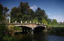
 A bridge over the River Lambro in the park | |
 | |
| Type | Municipal |
| Location | Monza |
| Area | c. 688 ha |
| Created | 1808 |
| Status | Open all year |
Monza Park (Parco di Monza) is a large walled park in Monza, Lombardy, northern Italy. Extending over an area of 688 hectares (6.88 km2), it is the fourth largest walled park in Europe, and the fourth largest enclosed one after la Mandria of Venaria Reale (Italy), Richmond Park in London (England) and Phoenix Park in Dublin (Ireland).
The park was commissioned by Napoleon's stepson Eugène de Beauharnais, during the French occupation of northern Italy, as external part of the garden of his royal palace (the Royal Villa of Monza); it was completed in 1808.
The park is crossed in its southern sector by the Lambro river. Some one third of the park is occupied by woods, while the rest is kept as lawn.
The Autodromo Nazionale Monza racetrack has been located inside the park since 1922.
