
Mount Ngauruhoe
| Mount Ngauruhoe |
|---|
Mount Ngauruhoe is an active stratovolcano in New Zealand. It is the youngest vent and highest peak in the Tongariro volcanic complex on the Central Plateau of the North Island, and first erupted about 2,500 years ago. Although seen by most as a volcano in its own right, it is technically a secondary cone of Mount Tongariro.
The volcano lies between the active volcanoes of Mount Tongariro to the north and Mount Ruapehu to the south, to the west of the Rangipo Desert 25 kilometres to the south of the southern shore of Lake Taupo.
It erupted 45 times in the 20th century, making it one of the world's most active volcanoes in that period. It last erupted in 1975. Fumaroles exist inside the inner crater and on the rim of the eastern, outer crater.
There are several possible explanations for the mountain's name. The most plausible is Nga Uru Hoe, meaning "throwing heated stones".
In the early 2000s Mount Ngauruhoe was used as a stand-in for the fictional Mount Doom in Peter Jackson's The Lord of the Rings movie trilogy, achieving worldwide exposure.
Recent Activity
During the last three weeks there has been a significant change in the number and magnitude of low frequency earthquakes being recorded by seismographs around Mt Ngauruhoe.
Initial analysis indicates these earthquakes are occurring about 4 km deep beneath Ngauruhoe, but they could be shallower.
"Seismic activity at Ngauruhoe remains elevated, although it has declined to 10 to 20 volcanic earthquakes per day from a peak of approximately 50 per day in early June. The largest earthquakes are approximately magnitude 1. Locations for the earthquakes place them 1 to 4 km deep and slightly to the north or east of the summit. The accuracy of these locations is hampered by the earthquakes being very small, as they are recorded on only three or four permanent seismographs." more.. GNS Alert Bulletin
See also
Gallery
-
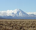 View from the Desert Road.
 -
 Mount Ngauruhoe
 -
 Aerial photo of crater
 -
 View from the starting climb of Red Crater


References
- ^ "Landcare document" (PDF). Retrieved 2007-09-12.