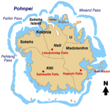
Nett

Nett also written as Net, is one of the administrative divisions of Pohnpei State, Federated States of Micronesia.[1]
Description
Nett is one of the six municipalities located in the main island of Pohnpei. It corresponds to the north-central sector of the island.
The population was 5,139 as of 2000.[2] Nett municipality formerly included Kolonia, now a separate administrative division.
See also
- Madolenihmw
- Kitti (municipality)
- U, Pohnpei
- Sokehs
- Kapingamarangi
- Pingelap
- Sapwuahfik
- Nukuoro
- Mokil
- Kolonia
- Oroluk
- Palikir
References
External links
- Thomas Panholzer & Rufino Mauricio, Place Names of Pohnpei Island, ISBN 978-1-57306-166-7
