
Nieuwezijds Achterburgwal
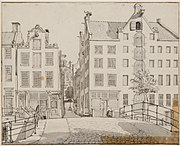
 Het woonhuis van Vondel, Spuistraat 188, voorheen de Nieuwezijds Achterburgwal. Cornelis de Kruyff, c. 1800 | |
 | |
| Location | Amsterdam |
|---|---|
| Postal code | 1016 |
| Coordinates | 52°22′26″N 4°53′24″E / 52.373818°N 4.889964°E |
The Nieuwezijds Achterburgwal (New Side Behind Bastion Wall[a]) is a former street and canal in Amsterdam, the Netherlands. From around 1380 to 1450 it was part of the town's defenses. The canal was filled in in 1866, and is now Spuistraat.
History
In 1342 a simple earthen embankment was raised to protect the small town of Amsterdam, with a narrow canal in front of it where the Oudezijds Voorburgwal and Nieuwezijds Voorburgwal are today. As the town grew, new defenses were built further out: the Oudezijds Achterburgwal in 1367 and the Nieuwezijds Achterburgwal in 1380.[1] At this time the town's population was between 3,000 and 5,000, so construction of the fortifications would have been a huge effort. Amsterdam continued to grow, and in 1425 a broad new canal was dug further east of the town, where the Geldersekade and Kloveniersburgwal are today. Twenty five years later the Singel was completed round the west side of the city from the IJ to the Amstel.[2] The Nieuwezijds Voorburgwal no longer had a defensive purpose.
The brewery "De Hooiberg" was established on the Nieuwezijds Voorburgwal in 1592 on the site now occupied by the Hotel Die Port van Cleve. It was very successful, and in the years that followed, the building was expanded between the Nieuwezijds Voorburgwal and Nieuwezijds Voorburgwal. In 1863 the building complex was bought by Gerard Adriaan Heineken. After the canal was filled in, Heineken moved his brewery to the Stadhouderskade in Amsterdam.[citation needed] In May 1621 the printer and newspaper publisher Broer Jansz (1579–1652) settled on the Nieuwezijds Achterburgwal in a house named the "Silvere Can". He remained here for the rest of his career.[3]
The Donkere Sluis was built between 1625 and 1657 connecting the Singel to the Nieuwezijds Voorburgwal via the Nieuwezijds Achterburgwal. It provided a water route between the old city and the expansion beyond the Singel.[4] Without it, water traffic had to use the Kattengat or the Boerenverdriet. With the third expansion, the grachtengordel (canal belt) had cross-canals at regular intervals, solving the problem. Since land was in short supply, in the 1661 the City horse stables were built over the Donkere Sluis.[5] By the mid 1800s the canal mainly held warehouses and stables near the houses on Nieuwezijds Voorburgwal.[6] The canal was a long, smelly ditch with uneven and narrow quays.[7]
The city council decided to fill in the Nieuwezijds Achterburgwal on 28 January 1866.[7] The canal was filled in 1868 at the same time as the Kattegat, a ditch between Nieuwezijds Achterburgwal and the Stroomarkt. The purpose was to improve public health and to make the city more accessible.[6] The change seems to have been popular with the residents. The name was changed to Spuistraat in November 1867 and a double row of chestnut trees was planted along it.[7] Spuistraat became part of the route of the Blue Tram, an electric tram that ran from Amsterdam via Haarlem to Zandvoort.[6]
-
 Nieuwezijds Achterburgwal, 147-151, with entrance to Huiszittensteeg. c. 1770. Gerrit Lamberts
 -
 Nieuwe Zijds Achterburgwal, looking south, left bridge over Kattegat. Before 1900
 -
 1625 map showing Dam Square, Nieuwezijds Voorburgwal, Nieuwezijds Achterburgwal and the Singel
 -
 De Hooiberg brewery on Nieuwezijds Achterburgwal in 1864
,_Afb_010097001237.jpg)

_Dam_Square_westward.jpg)

Notes
- ^ In the Middle Ages Amsterdam lay on both sides of the Amstel river where it entered the IJ body of water from the south. The eastern part was the Oudezijd (old side) and the western part was the Nieuwezijd (new side). When the first burgwal (bastion wall) was built, the Voorburgwal ran in front of it as a moat. When the second bastion wall was built further out, the Achterburgwal ran behind it, on the town side. The name "Nieuwezijds Achterburgwal" refers to the canal that ran behind (on the city side of) the second bastion wall on the new side of Amsterdam.
Citations
- ^ Zweefmakreel 2008.
- ^ Geert Mak 2010, p. 36.
- ^ Arthur der Weduwen 2017, p. 261.
- ^ Theo Bakker, p. 3.
- ^ Theo Bakker, p. 4.
- ^ a b c 400 jaar Amsterdamse grachten.
- ^ a b c Peter Paul de Baar 2018.
Sources
- "400 jaar Amsterdamse grachten: Nieuwezijds Achterburgwal", De Echo, 16 April 2013, retrieved 2019-07-30
- Arthur der Weduwen (19 April 2017), Dutch and Flemish Newspapers of the Seventeenth Century (2 Vols.), BRILL, ISBN 978-90-04-34189-0, retrieved 30 July 2019
- Geert Mak (30 September 2010), Amsterdam: A brief life of the city, Random House, ISBN 978-1-4090-0085-3, retrieved 30 July 2019
- Gerrit_de_Broen (1737), Amsterdam, retrieved 2019-07-30
- Peter Paul de Baar (26 September 2018), "Stinksloot wordt Spuistraat", Ons Amsterdam, retrieved 2019-07-30
- Theo Bakker, het raadsel Donkere Sluis (PDF), retrieved 2019-07-30
- Zweefmakreel (22 April 2008), Nieuwezijds Achterburgwal, retrieved 2019-07-30
.jpg)
_2-1.jpg)
.jpg)