Ojimaya Station
Appearance
This article needs additional citations for verification. (September 2016) |
Ojimaya Station 小島谷駅 | |||||
|---|---|---|---|---|---|
 Ojimaya Station in March 2006 | |||||
| General information | |||||
| Location | Ojimaya, Nagaoka-shi, Niigata-ken 949-4511 Japan | ||||
| Operated by | |||||
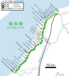
| Line(s) | ■ Echigo Line | ||||
| Distance | 32.4 km from Kashiwazaki | ||||
| Platforms | 2 side platforms | ||||
| Tracks | 2 | ||||
| Other information | |||||
| Website | www | ||||
| History | |||||
| Opened | 20 April 1913 | ||||
| Previous names | Yoita Station (to 1915) | ||||
| Passengers | |||||
| FY2010 | 107 daily | ||||
| |||||
Ojimaya Station (小島谷駅, Ojimaya-eki) is a railway station in Niigata, Niigata, Japan, operated by East Japan Railway Company (JR East).
Lines
Ojimaya Station is served by the Echigo Line, and is 32.4 kilometers from terminus of the line at Kashiwazaki.
Station layout
The station consists of two ground-level opposed side platforms serving two tracks. The platforms are connected by a footbridge.
The station is unattended. Suica farecard cannot be used at this station[1].
Platforms
| 1 | ■ Echigo Line | for Yoshida and Niigata for Higashi-Sanjō for Kashiwazaki |
| 2 | ■ Echigo Line | for Kashiwazaki (peak times only) |
Adjacent stations
| « | Service | » | ||
|---|---|---|---|---|
| Echigo Line | ||||
| Myōhōji | - | Kirihara | ||
History
The station opened on 20 April 1913 as Yoita Station (与板駅, Yoita-eki). It was renamed to its present name on 1 October 1915. With the privatization of Japanese National Railways (JNR) on 1 April 1987, the station came under the control of JR East.
Surrounding area
- Washima Post Office
- former Kashima village hall
- Japan National Route 116
See also
References
- ^ Suica>利用可能エリア>新潟エリア>拡大図 [Suica Area in Niigata] (in Japanese). Japan: JR East. Retrieved 17 November 2017.
External links
Wikimedia Commons has media related to Ojimaya Station.


