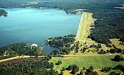
Okatibbee Dam

Okatibbee Dam is a dam in Lauderdale County, Mississippi.
The earthen gravity dam was constructed in 1968 by the United States Army Corps of Engineers with a height of 72 feet and a length of 6620 at its crest. It impounds Okatibbee Creek for flood control and municipal drinking water. The dam is owned and operated by the Corps of Engineers.[1]
The reservoir it creates, Okatibbee Lake, has a water surface of 5.9 square miles, about 28 linear miles of shoreline, a maximum capacity of 59,481 acre-feet, and a normal storage capacity of 46,538 acre-feet.[2] Recreation includes boating, fishing, camping, hunting, and enjoying the five parks maintained by the Corps, one full service campground and four day-use parks. Directly north of the lake is the state's Okatibbee State Wildlife Area.
References
- ^ http://findlakes.com/northcentral_louisiana_lakes_n32w92.htm
- ^ "Archived copy". Archived from the original on January 13, 2008. Retrieved June 9, 2008.
{{cite web}}: Unknown parameter|deadurl=ignored (|url-status=suggested) (help)CS1 maint: archived copy as title (link)
