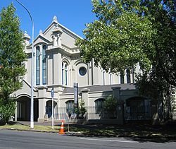
University House, Auckland

The Old Synagogue is a 19th-century building at 19A Princes Street in central Auckland, New Zealand, that was formerly a synagogue. It is now called University House, and is part of the University of Auckland.
A Jewish community had been present in Auckland since its founding in 1840. The synagogue building, which blends Moorish and classical elements, was designed and built by Edward Bartley in 1884–1885,[1] and the synagogue opened on 9 November 1885.[2] In 1967 the congregation moved to larger premises on Greys Avenue, overlooking Myers Park.[3]
The old synagogue building was left vacant and deteriorated over the following years, until it was carefully restored in 1989 to serve as a branch of the National Bank.[4] The University of Auckland has leased it since 2003, and it now houses the University's External Relations offices.[5]
The building has a Category I listing with the New Zealand Historic Places Trust.[6]
References
- ^ Heritage Walks - The Engineering Heritage of Auckland, Tourism Auckland. ISBN 0-908960-46-8.
- ^ Mara Weiss. The Jewish Virtual History Tour, New Zealand. Retrieved 12 May 2010.Retrieved 12 May 2010.
- ^ Anéne Cusins-Lewer and Julia Gatley. The 'Myers Park Experiment' (1913-1916) and its Legacy in Auckland. Retrieved 12 May 2010.
- ^ Old Jewish Synagogue, January 2006, Architecture Archive, University of Auckland Library. Retrieved 12 May 2010.
- ^ Diana Morrow. The University Heritage Trail, University of Auckland Business School. Retrieved 12 May 2010.
- ^ "Synagogue (Former)". New Zealand Heritage List/Rārangi Kōrero. Heritage New Zealand. Retrieved 2010-05-13.
