
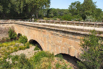
Orbiel Aqueduct
Pont-canal de l'Orbiel | |
|---|---|
| Coordinates | 43°12′52.39″N 2°26′21.51″E / 43.2145528°N 2.4393083°E |
| Carries | Canal du Midi |
| Crosses | Orbiel River |
| Locale | Trèbes |
| Characteristics | |
| Trough construction | Masonry |
| Pier construction | Masonry |
| No. of spans | 3 |
| Location | |
 | |
The Orbiel Aqueduct (French: Pont-canal de l'Orbiel) is one of several aqueducts on the Canal du Midi. Until its building, the canal crossed the River Orbiel on the level. A dam on the Orbiel was demolished and replaced with the Aqueduct. It was built in 1686-87 by Antoine Niquet and designed by Marshal Sebastien Vauban,[1] It is found in the city of Trèbes.
See also
References
- ^ Rolt, L. T. C. (1973). From Sea to Sea. Ohio University Press. ISBN 0-8214-0152-1.
{{cite book}}: Cite has empty unknown parameter:|coauthors=(help)
External links
This Occitania geographical article is a stub. You can help Wikipedia by expanding it. |
This article about a bridge in France is a stub. You can help Wikipedia by expanding it. |