Oxentea
Appearance
Oxentea
Оксентя (ucraineană) | |
|---|---|
| Country | |
| Government | |
| • Mayor | Valeriu Rusu (Independent[1]) |
| Area | |
| • Total | 16.10 km2 (6.22 sq mi) |
| Elevation | 66 m (217 ft) |
| Population (2004) | 2,794 de oameni49.46% fiind bărbați iar 50.54% femei |
| Time zone | UTC+2 (EET) |
| • Summer (DST) | UTC+3 (EEST) |
| Postal code | MD-4578[2] |
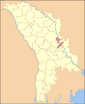
Oxentea is a commune in Dubăsari district, Moldova. It is composed of a single village, Oxentea.
47°23′N 29°07′E / 47.383°N 29.117°E
References
- ^ "Lista primarilor aleși în cadrul Alegerilor Locale Generale din 14 iunie 2015" (in Romanian). Central Election Commission of Moldova. 2015. Retrieved 2016-04-15.
- ^ "Coduri poștale - Republica Moldova" (in Romanian). Poșta Moldovei. Retrieved 2016-05-01.

