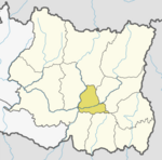
Pakhribas Municipality
Pakhribas
पाख्रिवास | |
|---|---|
 Pakhribas Bazaar | |
| Country | |
| Zone | Kosi Zone |
| District | Dhankuta District |
| Population (1991) | |
| • Total | 4,508 |
| Time zone | UTC+5:45 (NST) |
| Postal code | 56809 |
| Area code | 026 |
| Website | www.pakhribasmun.gov.np |
Pakhribas is a village development committee in Dhankuta District in the Kosi Zone of eastern Nepal. At the time of the 1991 Nepal census it had a population of 4508 people living in 890 individual households.[1] One story says that Pakhribas got its name from a Pakhri tree which used to stand at the center of the present day Pakhribas Bazaar some decades ago. The porters, transporting goods to Bhojpur and Sankhuwasabha, usually rested under the Pakhri tree and referred to the tree as their baas (lodge) for the night. Hence, the name Pakhribas. Pakhribas has 9 schools, among which three are private schools(Sheetala Devi English Secondary School at Pakhribas-7, Sayapatri English Medium School and Dibyajyoti English School at Pakhribas-3). Jalapa Devi Higher Secondary School provides higher education in science, humanities and arts faculty. Jalapa also has CTEVT annexed sub-overseer course. Pakhribas has three prominent Hindu shrines, one Buddhist monastery and two churches. The churches belong to the Protestant faith. Aashish Church situated in Pakhribas-8 is supposed to be the first of its kind in the Free Presbyterian faith.[2]
References
- ^ "Nepal Census 2001". Nepal's Village Development Committees. Digital Himalaya. Retrieved 24 November 2008.
- ^ "Pakhribas". Retrieved 10 August 2012.
{{cite web}}:|section=ignored (help)
External links
![]() Media related to Pakhribas at Wikimedia Commons
Media related to Pakhribas at Wikimedia Commons

