Pala Parish
Pala Parish
Pala vald | |
|---|---|
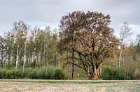
 Lümati elm tree | |
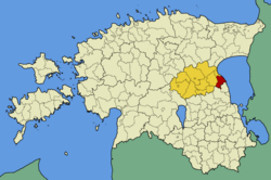
 Pala Parish within Jõgeva County. | |
| Country | |
| County | |
| Administrative centre | Pala |
| Area | |
| • Total | 156.71 km2 (60.51 sq mi) |
| Population (01.01.2004) | |
| • Total | 1,363 |
| • Density | 8.7/km2 (23/sq mi) |
| Website | www |
Pala Parish (Estonian: Pala vald) is a former rural municipality in eastern Estonia. It was a part of Jõgeva County. The municipality had a population of 1,363 (as of 1 January 2004) and covered an area of 156.71 km². The population density was 8.7 inhabitants per km². There were a total of 23 villages in Pala Parish.
Administrative centre of the municipality was Pala village with population of 276. It was first mentioned in 1582 as Pallawes. There are a school, a musical school, a library and a cultural centre in Pala village.
Settlements
- Villages
Assikvere - Äteniidi - Haavakivi - Kadrina - Kirtsi - Kodavere - Kokanurga - Lümati - Metsanurga - Moku - Nõva - Pala - Perametsa - Piibumäe - Piirivarbe - Punikvere - Raatvere - Ranna - Sääritsa - Sassukvere - Sõõru - Tagumaa - Vea
External links
58°40′01″N 27°01′19″E / 58.667°N 27.022°E


