Palmeira dos Índios
Appearance
Palmeira dos Índios | |
|---|---|
Municipality | |
 | |
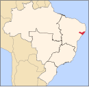
 Location of Palmeira dos Índios in the State of Alagoas | |
| Coordinates: 9°24′25″S 36°37′40″W / 9.40694°S 36.62778°W | |
| Country | |
| State | Alagoas |
| Mesoregion | Agreste Alagoano |
| Microregion | Palmeira dos Índios |
| Founded | 1835 |
| Government | |
| • Mayor | Julio Cézar |
| Area | |
| • Total | 460.610 km2 (177.843 sq mi) |
| Elevation | 290 m (950 ft) |
| Population (2010.[1]) | |
| • Total | 70,434 |
| • Density | 150/km2 (400/sq mi) |
| Demonym | Palmeirenses |
| Time zone | UTC-3 (UTC-3) |
| Website | Official website |
Palmeira dos Índios is a municipality located in the western of the Brazilian state of Alagoas. As of 2010[update], it has a population of around 70,000.
The city is situated on Alagoas backwood region. The Brazilian writer, Graciliano Ramos, was its mayor in 1927. It is the seat of the Roman Catholic Diocese of Palmeira dos Índios.
See also
References
![]() Media related to Palmeira dos Índios at Wikimedia Commons
Media related to Palmeira dos Índios at Wikimedia Commons


