Pangai

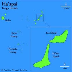
Pangai is the administrative capital village of the Haʻapai Group in Tonga.
The Town
The village is on the western shore of Lifuka and has about 2,000 inhabitants [1]. The coordinates are 19°48′12″S 174°20′56″W / 19.80333°S 174.34889°W
The village center is around the Catholic church (Siasi Katolika) and Holopeka Road by the harbor. There are only a few shops and markets and one bank.
There are few historic sites besides the church and a few Colonial styled houses.
The island's Pilolevu Airport (Lifuka Island Airport, airport code "HPA") is situated about 5 km north of Pangai.
History
The methodist missionary Shirley Waldemar Baker who was prime minister of Tonga under king George Tupou I died in Pangai on 16 November 1903. His grave and monument in the cemetery still stand as a touristic attraction.
