
Papelotte

Papelotte Farm (French: Ferme de la Papelotte) is located on the Waterloo battlefield and formed part of the defence system of the Duke of Wellington on 18 June 1815.
The defenders were soldiers from the Duchy of Nassau, but the French managed to capture it and hold it for short while.[1] It was located to the north-east of the battlefield on Wellington's left (Napoleon's right).
-
 The southern view farm
 -
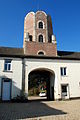 The porch and octagonal tower seen from the courtyard
 -
 The barn
 -
 The arches of the garages


See also
Notes
- ^ Mardaga 1998, p. 581.
References
- Mardaga, Pierre, ed. (1998), Le Patrimoine monumental de la Belgique, Wallonie 2, Brabant, Arrondissement de Nivelles (in French), p. 581
Further reading
- "Ferme de la Papelotte - Wiki". Braine-l'Alleud (in French). 7 June 2018.
- generalpicton (24 October 2017). "The battle for Papelotte". Waterloo in 20mm. Retrieved 7 June 2018.
- "Waterloo Ferme Papelotte :Maquetland.com:: Le monde de la maquette". :Maquetland.com:: Le monde de la maquette (in French). Retrieved 7 June 2018.
50°40′49″N 4°26′02″E / 50.68028°N 4.43389°E
This article about a Belgian building or structure is a stub. You can help Wikipedia by expanding it. |