Pas de Bellecombe-Jacob
| Pas de Bellecombe | |
|---|---|
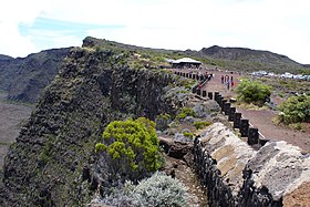
 Parking lot at Pas de Bellecombe | |
| Elevation | 2311 m |
| Location | Réunion, Indian Ocean |
| Range | Piton de la Fournaise |
| Coordinates | 21°13′20″S 55°41′20″E / 21.22222°S 55.68889°E |
Pas de Bellecombe is a mountain pass and vista point overlooking Enclos Fouqué, the last caldera formed by Piton de la Fournaise, the active volcano on the eastern side of Réunion island (a French department) in the Indian Ocean.
It is named after Guillaume Léonard de Bellecombe, governor of La Réunion during the 18th century.
Location

The Pas de Bellecombe is situated over the caldera rim cliffs, at a 2311 m elevation, and offers a good point of view over the northeast part of the caldera, including a small crater called Formica Leo.
Wikimedia Commons has media related to Piton de la Fournaise.

