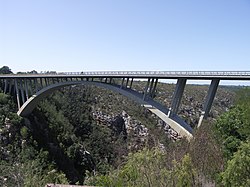
Paul Sauer Bridge
Paul Sauer Bridge | |
|---|---|
 The N2 concrete arch bridge over the Storms River | |
| Coordinates | 33°58′6.56″S 23°55′53.57″E / 33.9684889°S 23.9315472°E |
| Carries | N2 national highway. |
| Crosses | Storms River |
| Locale | Eastern Cape, South Africa |
| Characteristics | |
| Design | Arch bridge |
| Material | Concrete |
| Height | 120 metres (394 ft) |
| Longest span | 100 metres (328 ft) |
| History | |
| Designer | Riccardo Morandi |
| Construction start | 1953 |
| Construction end | 1956 |
| Construction cost | ₤100,000[1] |
| Location | |
 | |
The Paul Sauer Bridge, also known as the Storms River Bridge, is an arch bridge over the Storms River in the Eastern Cape of South Africa. The bridge is located on the Garden Route section of National Route 2, between Cape Town and Port Elizabeth. At a maximum height of 120 metres (394 ft) above the Storms River, it was the highest concrete arch in Africa until the Bloukrans Bridge, 216 metres (709 ft), opened on the same road in 1984.
Construction

The bridge was designed by Italian engineer Riccardo Morandi, and constructed between 1953 and 1956. It spans 100 metres (328 ft) and sits 120 metres (394 ft) above the river.[2]
The main arch structure was constructed in a unique fashion: each half of the two (adjacent) arches was built with climbing formwork in an essentially vertical position on opposite sides of the gorge. These were then rotated and lowered into position to meet at the centre, thus forming the completed arch structure. The Paul Sauer Bridge was renovated in 1986.
References
- ^ "The history of the Storms River Bridge". Retrieved 3 August 2014.
- ^ http://www.highestbridges.com/wiki/index.php?title=Paul_Sauer_Bridge
External links
