Pirates Well
Pirates Well | |
|---|---|
| Coordinates: 22°25′58″N 73°06′03″W / 22.43278°N 73.10083°W | |
| Country | |
| Island | Mayaguana |
| District | Mayaguana |
| Population (2012) | |
| • Total | 235 |
| Time zone | UTC-5 (Eastern Time Zone) |
| Area code | 242 |
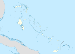
Pirates Well is a town in the Bahamas, located on Mayaguana island. It has a population of 235 (2012 estimates).[1] Pirates Well is home to a well, clearly marked by a sign and circled by stones and mortar, that was dug by buccaneers in the 16th century, hence the name.[2] The Baycaner Beach Resort is located in Pirates Well.[3]
It is 500 km southeast of the capital Nassau. Pirates Well is 5 meters above sea level.[4] Average annual temperature in the village is 25 ° C . The warmest month is August, when the average temperature is 28 ° C, and the coldest is January, with 23 ° C.[5] The average annual average is 1,026 millimeters. The rainiest month is October, with an average of 244 mm rainfall, and the driest is March, with 9 mm rainfall.[6]
During Hurricane Irma the sea wall was damaged and several power lines were down in Pirates Well but there was no serious damage to houses.[7]
References
- ^ World Gazetteer
- ^ The Pirate's Well Bahamas GeoTourism
- ^ Baycaner Beach Resort Bahamas GeoTourism
- ^ Pirates Well at GeoNames.org
- ^ NASA Earth Observations Data Set Index
- ^ NASA Earth Observations: Rainfall (1 month - TRMM)
- ^ Devastation Left In Irma’S Wake Tribune242

