Ponta Moreia
Ponta Moreia | |
|---|---|
 Ponta Moreia, its location is in the north of the island | |
| Coordinates: 15°20′25″N 23°44′33″W / 15.34016°N 23.74253°W | |
| Location | Northern Santiago, Cape Verde |
| Offshore water bodies | Atlantic Ocean |
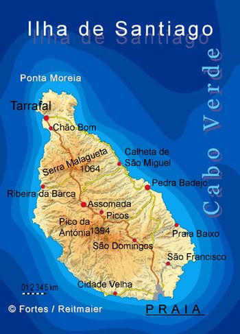
Ponta Moreia is the northernmost point of the island of Santiago, Cape Verde. It is about 2 km north of the nearest village, Fazenda and around 5 km north of Tarrafal. It has a small headland. Its length is about 800 meters long and its width ranges from 500 meters in the north and to 800 meters in the south. Two tiny sandy beaches are located at the edge of the headlands. Two rocky islets lie west of the headland. Nearby points are Ponta Bicuda 5 km east and Ponta da Fazenda less than 2 km west.
About 10 km immediately to the north has a depth of 1,000 meters and that portion forms a part of the Cape Verde Rise. 20-30 km north has the deepest portion being about 3,000 meters below sea level.
Near the point has a homonymous lighthouse located near the point at the elevation between 10 and 20 meters above sea level.[1][2]
During the Ice Age, the point then unnamed was about a kilometer north. Around it has a small unpaved road (Caminho da Ponta Moreia) that connects with Tras os Montes and the highway connecting Praia and Tarrafal via Pedra Badejo.
On January 5, 75 AD, a total solar eclipse took place and the greatest eclipse was in that area (15.5 N, 23.7 W) which was about 20 miles (25 km) northwest of the cape and headed up another 20 miles, its umbral portion width was 57 Roman miles (87 km) wide,[3] and stretched down to Serra da Malagueta.
The island along with the point was first discovered by António da Noli in 1460. Before the northern part was settled around the 16th century, the area was forested. The area around the point was first settled around the mid to late 16th century.
The main point was mentioned as "Ponta Bikkude" (Bicuda) in the 1747 French/Dutch map by Jacques Nicolas Bellin.[4] which is located to the east. Another point named Ponta das Bicudas on the island is located in the south just east of Praia at Praia Harbor.
In the 1950s, the geography was barren, in the 1990s, the area became forested which it has since.
References
- ^ "Ponta Moreia". Lighthouses in Cape Verde. Direcção Geral da Marinha e Portos (DGMP). Retrieved September 11, 2010.[permanent dead link]
- ^ "Ponta_Moreia". University of North Carolina at Chapel Hill The Lighthouse Directory. 25 September 2009. Retrieved 11 September 2010.
- ^ "Solar eclipse of January 5, 75 AD". NASA. Retrieved March 11, 2017.
- ^ Jacques-Nicolas Bellin; Pieter de Hondt (1747). "Carte des Isles du Cap Verd = Kaart van de Eilanden van Kabo Verde" (in French).


