Ponta Negra

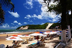
Ponta Negra (lit. "Black Tip") is a famous beach and neighborhood located in the Brazilian city of Natal, the capital of the state of Rio Grande do Norte. Located in the extreme south of the beach is the Morro do Careca (Bald Hill), a large dune and an iconic landmark of the city. Located in the extreme north of the beach is the Via Costeira (Coastal Way), a long coastal road that connects Ponta Negra with several other beaches of the city, such as Areia Preta and Praia dos Artistas.
The beach is completely urbanized and there are several shops, restaurants, bars, night clubs, and hotels.
The sand itself is lined with "tents", or huts, called "barracas" that serve food and drinks to beachgoers day and night.
A common sight on the beach are "jangadas", simple, multicolored, local fishing boats typical of northeastern Brazil.
See also
5°52′52″S 35°10′16″W / 5.88111°S 35.17111°W

